
Topografische Karte Maili
Interaktive Karte
Klicken Sie auf die Karte, um die Höhe anzuzeigen.
Über diese Karte
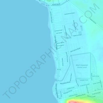
Name: Topografische Karte Maili, Höhe, Relief.
Durchschnittliche Höhe: 6 m
Minimale Höhe: 0 m
Maximale Höhe: 107 m
Māʻili (Hawaiian pronunciation: [maːˈʔili]) is a census-designated place (CDP) in the Waiʻanae District on the island of Oʻahu, City & County of Honolulu, Hawaiʻi, United States. In Hawaiian, māʻili means "pebbly", referring to rounded stones at the shore. Māʻili is located along Farrington Highway on Oʻahu's Leeward Coast, between Māʻili Beach Park to the west and Lualualei Valley to the east. It is located 1.4 miles south of the town of Waianae, separated by the Māʻiliʻili Stream, and 1.5 miles north of Nanakuli. As of the 2020 census, the town population was 11,535. Māʻili has one 7-Eleven, a gas station, and a few residential developments. The town is also home to several dairy farms and vegetable plots. Two tall, red antennae near the mouth of the Lualualei Valley are parts of the Navcom Radio Transmitting Facility, and were the tallest man-made structures in the Western Hemisphere at 1,503 feet when they were built in 1972. The town has an elevation of 20 feet (6.1 m).
Andere topografische Karten
Klicken Sie auf eine Karte, um ihre Topografie, ihre Höhe und ihr Relief anzuzeigen.
Akupu
United States > Hawaii > Honolulu County > Kapolei
Akupu, Kapolei, Honolulu County, Hawaii, United States
Durchschnittliche Höhe: 487 m
Ko Olina
United States > Hawaii > Honolulu County > Kapolei
Ko Olina, Kapolei, Honolulu County, Hawaii, United States
Durchschnittliche Höhe: 5 m