
Spenden
Rüste dich für dein nächstes Abenteuer:
Als Amazon-Partner verdient diese Website an qualifizierten Käufen, ohne zusätzliche Kosten für Sie.
Topografische Karte Dorking
Klicken Sie auf die Karte, um die Höhe anzuzeigen.
Spenden
Rüste dich für dein nächstes Abenteuer:
Als Amazon-Partner verdient diese Website an qualifizierten Käufen, ohne zusätzliche Kosten für Sie.
Über diese Karte
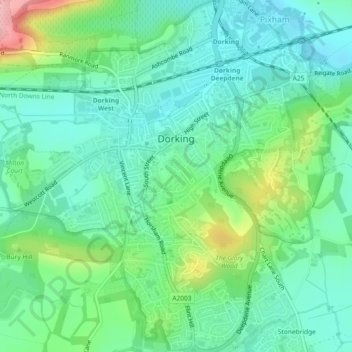
Name: Topografische Karte Dorking, Höhe, Relief.
Ort: Dorking, Mole Valley, Surrey, England, United Kingdom (51.21505 -0.34847 51.24386 -0.32072)
Durchschnittliche Höhe: 80 m
Minimale Höhe: 39 m
Maximale Höhe: 187 m
Spenden
Rüste dich für dein nächstes Abenteuer:
Als Amazon-Partner verdient diese Website an qualifizierten Käufen, ohne zusätzliche Kosten für Sie.
Andere topografische Karten
Klicken Sie auf eine Karte, um ihre Topografie, ihre Höhe und ihr Relief anzuzeigen.
Spenden
Rüste dich für dein nächstes Abenteuer:
Als Amazon-Partner verdient diese Website an qualifizierten Käufen, ohne zusätzliche Kosten für Sie.
Box Hill
United Kingdom > England > Surrey > Mole Valley > Pixham
The 15.8 km (9.8 mi) Box Hill Olympic circuit is generally cycled in an anticlockwise direction and begins to the south of the village of Mickleham with an ascent of the hill via the Zig Zag Road. From the National Trust Visitor Centre, the route turns eastwards, running along the escarpment and through the…
Durchschnittliche Höhe: 105 m
South Holmwood
United Kingdom > England > Surrey > Mole Valley > South Holmwood
Durchschnittliche Höhe: 116 m
Spenden
Rüste dich für dein nächstes Abenteuer:
Als Amazon-Partner verdient diese Website an qualifizierten Käufen, ohne zusätzliche Kosten für Sie.
Abinger Bottom
United Kingdom > England > Surrey > Mole Valley > Abinger
Durchschnittliche Höhe: 196 m
Spenden
Rüste dich für dein nächstes Abenteuer:
Als Amazon-Partner verdient diese Website an qualifizierten Käufen, ohne zusätzliche Kosten für Sie.
Abinger Roughs
United Kingdom > England > Surrey > Mole Valley > Abinger Hammer
Durchschnittliche Höhe: 141 m
Spenden
Rüste dich für dein nächstes Abenteuer:
Als Amazon-Partner verdient diese Website an qualifizierten Käufen, ohne zusätzliche Kosten für Sie.
Spenden
Rüste dich für dein nächstes Abenteuer:
Als Amazon-Partner verdient diese Website an qualifizierten Käufen, ohne zusätzliche Kosten für Sie.
Spenden
Rüste dich für dein nächstes Abenteuer:
Als Amazon-Partner verdient diese Website an qualifizierten Käufen, ohne zusätzliche Kosten für Sie.
Box Hill
United Kingdom > England > Surrey > Mole Valley > Pixham
The 15.8 km (9.8 mi) Box Hill Olympic circuit is generally cycled in an anticlockwise direction and begins to the south of the village of Mickleham with an ascent of the hill via the Zig Zag Road. From the National Trust Visitor Centre, the route turns eastwards, running along the escarpment and through the…
Durchschnittliche Höhe: 105 m
Spenden
Rüste dich für dein nächstes Abenteuer:
Als Amazon-Partner verdient diese Website an qualifizierten Käufen, ohne zusätzliche Kosten für Sie.
Spenden
Rüste dich für dein nächstes Abenteuer:
Als Amazon-Partner verdient diese Website an qualifizierten Käufen, ohne zusätzliche Kosten für Sie.