
Topografische Karte Ochotnica Dolna
Interaktive Karte
Klicken Sie auf die Karte, um die Höhe anzuzeigen.
Über diese Karte
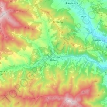
Name: Topografische Karte Ochotnica Dolna, Höhe, Relief.
Durchschnittliche Höhe: 715 m
Minimale Höhe: 376 m
Maximale Höhe: 1.215 m
Andere topografische Karten
Klicken Sie auf eine Karte, um ihre Topografie, ihre Höhe und ihr Relief anzuzeigen.
Gronków
Poland > Lesser Poland Voivodeship > Nowy Targ County
Gronków, gmina Nowy Targ, Nowy Targ County, Lesser Poland Voivodeship, Poland
Durchschnittliche Höhe: 628 m
Rabka-Zdrój
Poland > Lesser Poland Voivodeship > Nowy Targ County
Rabka-Zdrój, gmina Rabka-Zdrój, Nowy Targ County, Lesser Poland Voivodeship, 34-700, Poland
Durchschnittliche Höhe: 594 m
Nowy Targ
Poland > Lesser Poland Voivodeship > Nowy Targ County > Nowy Targ
Nowy Targ, Nowy Targ County, Lesser Poland Voivodeship, Poland
Durchschnittliche Höhe: 676 m