
Topografische Karte Wilmore
Interaktive Karte
Klicken Sie auf die Karte, um die Höhe anzuzeigen.
Über diese Karte
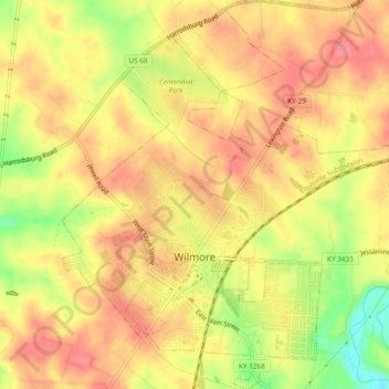
Name: Topografische Karte Wilmore, Höhe, Relief.
Ort: Wilmore, Jessamine County, Kentucky, 40390, United States (37.85131 -84.67643 37.88869 -84.63626)
Durchschnittliche Höhe: 272 m
Minimale Höhe: 223 m
Maximale Höhe: 297 m
Andere topografische Karten
Klicken Sie auf eine Karte, um ihre Topografie, ihre Höhe und ihr Relief anzuzeigen.
Nicholasville
United States > Kentucky > Jessamine County
Nicholasville, Jessamine County, Kentucky, 40356, United States
Durchschnittliche Höhe: 285 m
Pollard
United States > Kentucky > Jessamine County
Pollard, Jessamine County, Kentucky, United States
Durchschnittliche Höhe: 259 m