
Topografische Karte Bloemfontein
Interaktive Karte
Klicken Sie auf die Karte, um die Höhe anzuzeigen.
Über diese Karte
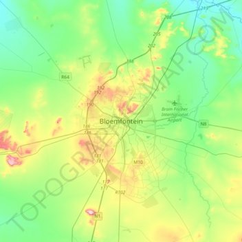
Name: Topografische Karte Bloemfontein, Höhe, Relief.
Durchschnittliche Höhe: 1.374 m
Minimale Höhe: 1.283 m
Maximale Höhe: 1.593 m
Situated at an elevation of 1,395 m (4,577 ft) above sea level, the city is home to approximately 520,000 residents and forms part of the Mangaung Metropolitan Municipality which has a population of 747,431. It was one of the host cities for the 2010 FIFA World Cup.
Andere topografische Karten
Klicken Sie auf eine Karte, um ihre Topografie, ihre Höhe und ihr Relief anzuzeigen.
Thaba Nchu 1
South Africa > Free State > Mangaung Metropolitan Municipality
Thaba Nchu 1, Mangaung Metropolitan Municipality, Free State, 9780, South Africa
Durchschnittliche Höhe: 1.527 m
Houtnek
South Africa > Free State > Mangaung Metropolitan Municipality
Houtnek, Mangaung Ward 41, Mangaung Metropolitan Municipality, Free State, South Africa
Durchschnittliche Höhe: 1.508 m
Bloemspruit
South Africa > Free State > Mangaung Metropolitan Municipality
Bloemspruit, Mangaung Ward 17, Mangaung Metropolitan Municipality, Free State, South Africa
Durchschnittliche Höhe: 1.335 m
Martindale Kleinplase
South Africa > Free State > Mangaung Metropolitan Municipality
Martindale Kleinplase, Mangaung Metropolitan Municipality, Free State, South Africa
Durchschnittliche Höhe: 1.381 m
Mangaung Ward 47
South Africa > Free State > Mangaung Metropolitan Municipality
Mangaung Ward 47, Mangaung Metropolitan Municipality, Free State, South Africa
Durchschnittliche Höhe: 1.378 m
Maselspoort
South Africa > Free State > Mangaung Metropolitan Municipality
Maselspoort, Mangaung Ward 44, Mangaung Metropolitan Municipality, Free State, South Africa
Durchschnittliche Höhe: 1.319 m
Thaba Nchu
South Africa > Free State > Mangaung Metropolitan Municipality
Thaba Nchu, Mangaung Metropolitan Municipality, Free State, 9780, South Africa
Durchschnittliche Höhe: 1.510 m
Mangaung Ward 38
South Africa > Free State > Mangaung Metropolitan Municipality
Mangaung Ward 38, Mangaung Metropolitan Municipality, Free State, South Africa
Durchschnittliche Höhe: 1.523 m
Botshabelo
South Africa > Free State > Mangaung Metropolitan Municipality
Botshabelo, Mangaung Metropolitan Municipality, Free State, 9781, South Africa
Durchschnittliche Höhe: 1.454 m
Krugersdrift
South Africa > Free State > Mangaung Metropolitan Municipality
Krugersdrift, Mangaung Ward 44, Mangaung Metropolitan Municipality, Free State, South Africa
Durchschnittliche Höhe: 1.248 m
Mangaung Metropolitan Municipality
South Africa > Free State > Mangaung Metropolitan Municipality
Mangaung Metropolitan Municipality, Free State, South Africa
Durchschnittliche Höhe: 1.401 m
Tierpoort
South Africa > Free State > Mangaung Metropolitan Municipality
Tierpoort, Mangaung Ward 18, Mangaung Metropolitan Municipality, Free State, South Africa
Durchschnittliche Höhe: 1.404 m
Motlatla
South Africa > Free State > Mangaung Metropolitan Municipality
Motlatla, Mangaung Metropolitan Municipality, Free State, 9780, South Africa
Durchschnittliche Höhe: 1.545 m