
Topografische Karte Mica Peak
Interaktive Karte
Klicken Sie auf die Karte, um die Höhe anzuzeigen.
Über diese Karte
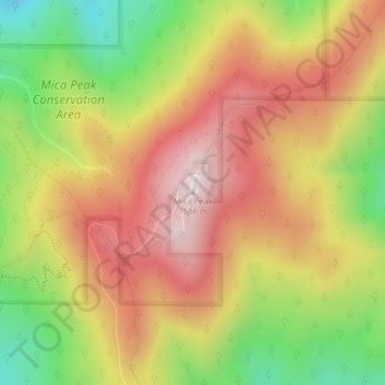
Name: Topografische Karte Mica Peak, Höhe, Relief.
Ort: Mica Peak, Spokane County, Washington, United States (47.57335 -117.08174 47.57345 -117.08164)
Durchschnittliche Höhe: 1.311 m
Minimale Höhe: 990 m
Maximale Höhe: 1.583 m
Mica Peak is the name of two separate mountain summits in the United States located approximately 5.49 miles (9 km) apart; one in Spokane County, Washington and the other in Kootenai County, Idaho. The two peaks are located along the same ridge, which separates the Spokane Valley and Rathdrum Prairie from the Palouse. The mountains have an elevation difference of only 31 ft (9.4 m) and are the southernmost peaks of the Selkirk Mountains.
Andere topografische Karten
Klicken Sie auf eine Karte, um ihre Topografie, ihre Höhe und ihr Relief anzuzeigen.
Spokane
United States > Washington > Spokane County
Spokane, Spokane County, Washington, United States
Durchschnittliche Höhe: 655 m
Spokane Valley
United States > Washington > Spokane County
Spokane Valley, Spokane County, Washington, United States
Durchschnittliche Höhe: 673 m
Hampton Bay
United States > Washington > Spokane County
Hampton Bay, Spokane County, Washington, United States
Durchschnittliche Höhe: 666 m
Nine Mile Falls
United States > Washington > Spokane County
Nine Mile Falls, Spokane County, Washington, 99026, United States
Durchschnittliche Höhe: 536 m
Otis Orchards-East Farms
United States > Washington > Spokane County
Otis Orchards-East Farms, Spokane County, Washington, United States
Durchschnittliche Höhe: 668 m
Mount Spokane State Park
United States > Washington > Spokane County
Mount Spokane State Park, Spokane County, Washington, United States
Durchschnittliche Höhe: 976 m
Country Homes
United States > Washington > Spokane County
Country Homes, Spokane County, Washington, 99251, United States
Durchschnittliche Höhe: 599 m
Mead
United States > Washington > Spokane County
Mead, Spokane County, Washington, 99021, United States
Durchschnittliche Höhe: 585 m
Mica
United States > Washington > Spokane County
Mica, Spokane County, Washington, 99023, United States
Durchschnittliche Höhe: 772 m
East Spokane
United States > Washington > Spokane County > Spokane Valley > East Spokane
East Spokane, Spokane Valley, Spokane County, Washington, 99260, United States
Durchschnittliche Höhe: 625 m
Riverfront Park
United States > Washington > Spokane County > Spokane
Riverfront Park, Spokane, Spokane County, Washington, United States
Durchschnittliche Höhe: 583 m
Beacon Hill
United States > Washington > Spokane County
Beacon Hill, Spokane County, Washington, 99211, United States
Durchschnittliche Höhe: 659 m
Orchard Prairie
United States > Washington > Spokane County
Orchard Prairie, Spokane County, Washington, United States
Durchschnittliche Höhe: 682 m