
Topografische Karte Johnson
Interaktive Karte
Klicken Sie auf die Karte, um die Höhe anzuzeigen.
Über diese Karte
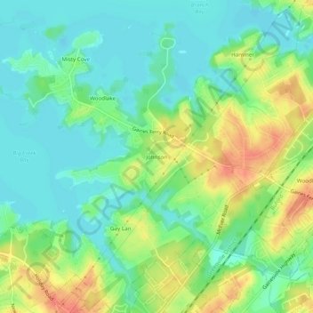
Name: Topografische Karte Johnson, Höhe, Relief.
Ort: Johnson, Hall County, Georgia, United States (34.15232 -83.99074 34.19232 -83.95074)
Durchschnittliche Höhe: 341 m
Minimale Höhe: 322 m
Maximale Höhe: 374 m
Andere topografische Karten
Klicken Sie auf eine Karte, um ihre Topografie, ihre Höhe und ihr Relief anzuzeigen.
Colony South
United States > Georgia > Hall County
Colony South, Hall County, Georgia, United States
Durchschnittliche Höhe: 328 m
Gainesville
United States > Georgia > Hall County
Gainesville, Hall County, Georgia, 30501, United States
Durchschnittliche Höhe: 346 m
Scoutland
United States > Georgia > Hall County > Scoutland
Scoutland, Hall County, Georgia, 30506, United States
Durchschnittliche Höhe: 343 m
Lula
United States > Georgia > Hall County > Lula
Lula, Hall County, Georgia, 30554, United States
Durchschnittliche Höhe: 369 m