
Spenden
Rüste dich für dein nächstes Abenteuer:
Als Amazon-Partner verdient diese Website an qualifizierten Käufen, ohne zusätzliche Kosten für Sie.
Topografische Karte Pandi
Klicken Sie auf die Karte, um die Höhe anzuzeigen.
Spenden
Rüste dich für dein nächstes Abenteuer:
Als Amazon-Partner verdient diese Website an qualifizierten Käufen, ohne zusätzliche Kosten für Sie.
Pandi
Pandi is rich in many natural brooks coming from the mainland itself. In some remote areas the lands are still covered by bamboo trees that naturally thrive and multiplies. Some lands privately owned have mango plantations. In some areas that are privately owned are rock deposits being used for housing materials. The eastern area of Poblacion is gifted by the natural panoramic beauty of the scenery of Sierra Madre Mountains in Luzon. Owing to this the morning climate is always cloudy and cool in some areas of the town proper of Pandi, Bulacan. Some of the natural variations in topography of Pandi land areas have been evened out due to the urbanization of the town. The town's central area has been altered substantially by commercial establishments. Pandi was part of 2nd congressional district from 1987 to 2022. It was moved to 5th district along with Balagtas, Bocaue, and Guiguinto.
Spenden
Rüste dich für dein nächstes Abenteuer:
Als Amazon-Partner verdient diese Website an qualifizierten Käufen, ohne zusätzliche Kosten für Sie.
Über diese Karte
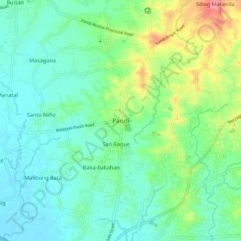
Name: Topografische Karte Pandi, Höhe, Relief.
Ort: Pandi, Bulacan, Central Luzon, 3022, Philippines (14.82541 120.91725 14.90541 120.99725)
Durchschnittliche Höhe: 27 m
Minimale Höhe: 3 m
Maximale Höhe: 90 m
Spenden
Rüste dich für dein nächstes Abenteuer:
Als Amazon-Partner verdient diese Website an qualifizierten Käufen, ohne zusätzliche Kosten für Sie.