
Topografische Karte Humboldt
Interaktive Karte
Klicken Sie auf die Karte, um die Höhe anzuzeigen.
Über diese Karte
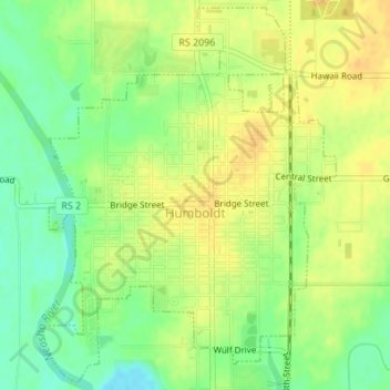
Name: Topografische Karte Humboldt, Höhe, Relief.
Ort: Humboldt, Allen County, Kansas, United States (37.79881 -95.45043 37.82478 -95.42459)
Durchschnittliche Höhe: 293 m
Minimale Höhe: 276 m
Maximale Höhe: 304 m
Andere topografische Karten
Klicken Sie auf eine Karte, um ihre Topografie, ihre Höhe und ihr Relief anzuzeigen.
Elsmore
United States > Kansas > Allen County
Elsmore, Allen County, Kansas, United States
Durchschnittliche Höhe: 322 m
Bassett
United States > Kansas > Allen County
Bassett, Allen County, Kansas, United States
Durchschnittliche Höhe: 294 m
Gas
United States > Kansas > Allen County
Gas, Allen County, Kansas, 66742, United States
Durchschnittliche Höhe: 310 m
Savonburg
United States > Kansas > Allen County
Savonburg, Allen County, Kansas, United States
Durchschnittliche Höhe: 318 m
Moran
United States > Kansas > Allen County
Moran, Allen County, Kansas, United States
Durchschnittliche Höhe: 334 m
Iola
United States > Kansas > Allen County
Iola, Allen County, Kansas, 66749, United States
Durchschnittliche Höhe: 296 m
La Harpe
United States > Kansas > Allen County
La Harpe, Allen County, Kansas, 66751, United States
Durchschnittliche Höhe: 313 m