
Topografische Karte Moab
Interaktive Karte
Klicken Sie auf die Karte, um die Höhe anzuzeigen.
Über diese Karte
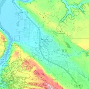
Name: Topografische Karte Moab, Höhe, Relief.
Ort: Moab, Grand County, Utah, 84532, United States (38.53621 -109.57965 38.60318 -109.51532)
Durchschnittliche Höhe: 1.357 m
Minimale Höhe: 1.200 m
Maximale Höhe: 1.746 m
Moab is just south of the Colorado River, at an elevation of 4,025 feet (1,227 m) on the Colorado Plateau. It is 18 miles (29 km) west of the Utah/Colorado state line. Via U.S. Route 191, it is 31 miles (50 km) south of Interstate 70 at Crescent Junction, and it is 54 miles (87 km) north of Monticello. Via Utah State Route 128 it is 46 miles (74 km) southwest of Cisco. The entrance to Arches National Park is 4 miles (6 km) north of Moab on US 191. Hurrah Pass is located on the trail between Moab and Chicken Corners.
Andere topografische Karten
Klicken Sie auf eine Karte, um ihre Topografie, ihre Höhe und ihr Relief anzuzeigen.
Westwater
United States > Utah > Grand County
Westwater, Grand County, Utah, United States
Durchschnittliche Höhe: 1.349 m
Cisco
United States > Utah > Grand County
Cisco, Grand County, Utah, 84515, United States
Durchschnittliche Höhe: 1.334 m
Rectory
United States > Utah > Grand County
Rectory, Grand County, Utah, United States
Durchschnittliche Höhe: 1.527 m
Delicate Arch
United States > Utah > Grand County
Delicate Arch, Delicate Arch Trail, Grand County, Utah, United States
Durchschnittliche Höhe: 1.409 m
Thompson Springs
United States > Utah > Grand County
Thompson Springs, Grand County, Utah, 84540, United States
Durchschnittliche Höhe: 1.583 m
Arches National Park
United States > Utah > Grand County
Arches National Park, Grand County, Utah, United States
Durchschnittliche Höhe: 1.476 m
Colorado River
United States > Utah > Grand County > Moab
Colorado River, Moab, Grand County, Utah, United States
Durchschnittliche Höhe: 1.668 m
Castle Valley
United States > Utah > Grand County
Castle Valley, Grand County, Utah, United States
Durchschnittliche Höhe: 1.610 m
Cottonwood Point
United States > Utah > Grand County
Cottonwood Point, Grand County, Utah, United States
Durchschnittliche Höhe: 2.346 m
La Sal Mountains Viewpoint
United States > Utah > Grand County
La Sal Mountains Viewpoint, Main Park Road, Grand County, Utah, 84532-2134, United States
Durchschnittliche Höhe: 1.347 m