

Topografische Karte Coquitlam
Klicken Sie auf die Karte, um die Höhe anzuzeigen.
Coquitlam
Southwest Coquitlam comprises the original core of the city, with Maillardville and Fraser River industrial sector giving way to the large residential areas of Austin Heights, colloquially referred to as "The Bump" due to its high and flat plateau topography. These older residences, with larger property dimensions, are increasingly being torn down and replaced with newer and larger homes. The Poirier Street area was the city's original recreational centre with the Coquitlam Sports Centre, Chimo Aquatic and Fitness Centre, and sports fields located there, while City Hall was previously located further south in Maillardville.
Über diese Karte
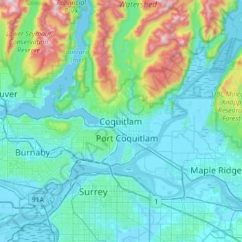
Name: Topografische Karte Coquitlam, Höhe, Relief.
Durchschnittliche Höhe: 230 m
Minimale Höhe: -4 m
Maximale Höhe: 1.532 m
Andere topografische Karten
Klicken Sie auf eine Karte, um ihre Topografie, ihre Höhe und ihr Relief anzuzeigen.
Town Centre Park
Canada > British Columbia > Metro Vancouver Regional District > Coquitlam
Durchschnittliche Höhe: 62 m
Blue Mountain Park
Canada > British Columbia > Metro Vancouver Regional District > Coquitlam
Durchschnittliche Höhe: 119 m
Mundy Park
Canada > British Columbia > Metro Vancouver Regional District > Coquitlam
Durchschnittliche Höhe: 139 m
Sheffield Park
Canada > British Columbia > Metro Vancouver Regional District > Coquitlam
Durchschnittliche Höhe: 153 m
Burke Mountain Pioneer Park
Canada > British Columbia > Metro Vancouver Regional District > Coquitlam
Durchschnittliche Höhe: 129 m