
Topografische Karte Carcar
Interaktive Karte
Klicken Sie auf die Karte, um die Höhe anzuzeigen.
Carcar
The land is generally level with less than 18% slope comprising 78.7% of the total land area. Areas with slopes ranging from 18 to 50% cover 19.3% of the total land area and those over 50% slope comprise approximately 1.9%. The highest recorded elevation is a little over 660 metres (2,170 ft) above sea level, located within the barangay of Napo.
Über diese Karte
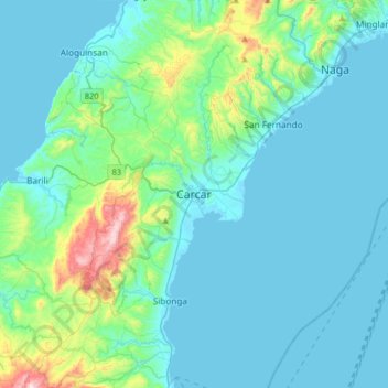
Name: Topografische Karte Carcar, Höhe, Relief.
Ort: Carcar, Cebu, Central Visayas, 6019, Philippines (9.94556 123.48067 10.26556 123.80067)
Durchschnittliche Höhe: 97 m
Minimale Höhe: -1 m
Maximale Höhe: 698 m
Andere topografische Karten
Klicken Sie auf eine Karte, um ihre Topografie, ihre Höhe und ihr Relief anzuzeigen.
Oslob
Generally, the area's topography is hilly and rolling, dominated by open grasslands and second-growth forests. There are fairly level and rolling plateaus and valleys spread throughout the interior. These are some of the most suitable areas for upland agriculture. The highest mountain peak is 800 metres (2,600…
Durchschnittliche Höhe: 99 m
Cordova
The surface of the town consists entirely of karstic limestone rock geologically associated with the Plio-Pleistocene Carcar Formation, dated to 2½–3 million years ago. The topography of Cordova is flat land, the highest point being only 10 metres (33 ft) above sea level.
Durchschnittliche Höhe: 0 m
Oslob
Generally, the area's topography is hilly and rolling, dominated by open grasslands and second-growth forests. There are fairly level and rolling plateaus and valleys spread throughout the interior. These are some of the most suitable areas for upland agriculture. The highest mountain peak is 800 metres (2,600…
Durchschnittliche Höhe: 99 m
Carnaza
The island's topography includes coastal plains, mangrove swamps, lagoons and semi-rounded hills. Its coastal plain constitutes about 9.7% while semi-rounded hills constitute the biggest portion of the island covering about 14.4% of the total area. The mangrove forest has an area of about 10.1 hectares or 5.8%…
Durchschnittliche Höhe: 0 m