
Topografische Karte Watauga Lake
Interaktive Karte
Klicken Sie auf die Karte, um die Höhe anzuzeigen.
Über diese Karte
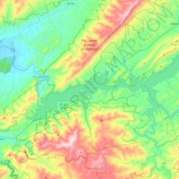
Name: Topografische Karte Watauga Lake, Höhe, Relief.
Ort: Watauga Lake, Carter County, Tennessee, 37640, United States (36.27698 -82.13142 36.38169 -81.92823)
Durchschnittliche Höhe: 755 m
Minimale Höhe: 469 m
Maximale Höhe: 1.298 m
According to the 2004 TVA River and Reservoir Operations Study, Watauga Lake is approximately 16.3 mi (26.2 km) long, with 104.9 mi (168.8 km) of shoreline. At the TVA summertime water level target "full pool", the lake surface covers 6,430 acres (26 km²) and the estimated depth of Watauga Lake is 265 feet (81 m) at the dam. At full pool, Watauga's elevation is the highest of all TVA lakes at 1,959 feet (597 m) above sea level.
Andere topografische Karten
Klicken Sie auf eine Karte, um ihre Topografie, ihre Höhe und ihr Relief anzuzeigen.
Elizabethton
United States > Tennessee > Carter County > Elizabethton > Elizabethton
Elizabethton, Carter County, Tennessee, 37643, United States
Durchschnittliche Höhe: 527 m
Roan Mountain
United States > Tennessee > Carter County
Roan Mountain, Carter County, East Tennessee, Tennessee, United States
Durchschnittliche Höhe: 1.418 m
Pine Crest
United States > Tennessee > Carter County
Pine Crest, Carter County, East Tennessee, Tennessee, United States
Durchschnittliche Höhe: 515 m
Tolley Town
United States > Tennessee > Carter County
Tolley Town, Carter County, East Tennessee, Tennessee, United States
Durchschnittliche Höhe: 896 m
Winner
United States > Tennessee > Carter County
Winner, Carter County, East Tennessee, Tennessee, United States
Durchschnittliche Höhe: 614 m
Roan Mountain State Park
United States > Tennessee > Carter County > Roan Mountain
Roan Mountain State Park, Roan Mountain, Carter County, East Tennessee, Tennessee, United States
Durchschnittliche Höhe: 988 m
Central
United States > Tennessee > Carter County
Central, Carter County, East Tennessee, Tennessee, United States
Durchschnittliche Höhe: 489 m
Roan Mountain
United States > Tennessee > Carter County
Roan Mountain, Carter County, East Tennessee, Tennessee, 37687, United States
Durchschnittliche Höhe: 926 m
Elk Mills
United States > Tennessee > Carter County
Elk Mills, Carter County, Tennessee, United States
Durchschnittliche Höhe: 749 m
Dogtown
United States > Tennessee > Carter County
Dogtown, Carter County, Tennessee, United States
Durchschnittliche Höhe: 617 m
Jane Bald
United States > Tennessee > Carter County
Jane Bald, Carter County, East Tennessee, Tennessee, United States
Durchschnittliche Höhe: 1.573 m
Watauga
United States > Tennessee > Carter County
Watauga, Carter County, East Tennessee, Tennessee, United States
Durchschnittliche Höhe: 465 m
Hunter
United States > Tennessee > Carter County
Hunter, Carter County, Tennessee, United States
Durchschnittliche Höhe: 706 m
Milligan
United States > Tennessee > Carter County > Elizabethton > Milligan
Milligan, Elizabethton, Carter County, Tennessee, 37605, United States
Durchschnittliche Höhe: 508 m
Hampton
United States > Tennessee > Carter County
Hampton, Carter County, East Tennessee, Tennessee, 37658, United States
Durchschnittliche Höhe: 674 m
Valley Park
United States > Tennessee > Carter County > Elizabethton > Valley Park
Valley Park, Elizabethton, Carter County, Tennessee, 37643, United States
Durchschnittliche Höhe: 515 m
Elizabethton
United States > Tennessee > Carter County
Elizabethton, Carter County, East Tennessee, Tennessee, United States
Durchschnittliche Höhe: 567 m