
Topografische Karte Sioux City
Interaktive Karte
Klicken Sie auf die Karte, um die Höhe anzuzeigen.
Über diese Karte
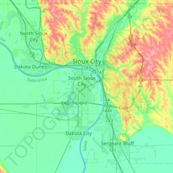
Name: Topografische Karte Sioux City, Höhe, Relief.
Ort: Sioux City, Woodbury County, Iowa, United States (42.37007 -96.49899 42.56542 -96.29956)
Durchschnittliche Höhe: 352 m
Minimale Höhe: 319 m
Maximale Höhe: 438 m
Sioux City is located at 42°29′44″N 96°23′26″W / 42.495668°N 96.390525°W / 42.495668; -96.390525.[1] Sioux City lies at an altitude of 1,135 ft (345.9 m) above sea level. Sioux City borders two states, South Dakota to the west-northwest and Nebraska to the west. According to the United States Census Bureau, the city has a total area of 59.63 sq mi (154.44 km2), of which 58.46 sq mi (151.41 km2) is land and 1.165 sq mi (3.02 km2) is water.[1]
Andere topografische Karten
Klicken Sie auf eine Karte, um ihre Topografie, ihre Höhe und ihr Relief anzuzeigen.
Cushing
United States > Iowa > Woodbury County
Cushing, Woodbury County, Iowa, United States
Durchschnittliche Höhe: 402 m
Sioux City
United States > Iowa > Woodbury County > Sioux City
Sioux City, Woodbury County, Iowa, 51101-1708, United States
Durchschnittliche Höhe: 361 m