
Topografische Karte Wilmington
Interaktive Karte
Klicken Sie auf die Karte, um die Höhe anzuzeigen.
Wilmington
On the western side of Market Street, the Piedmont topography is rocky and hilly, rising to a point that marks the watershed between the Brandywine River and the Christina River. This watershed line runs along Delaware Avenue westward from 10th Street and Market Street.
Über diese Karte
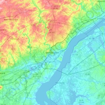
Name: Topografische Karte Wilmington, Höhe, Relief.
Durchschnittliche Höhe: 43 m
Minimale Höhe: -5 m
Maximale Höhe: 170 m
Andere topografische Karten
Klicken Sie auf eine Karte, um ihre Topografie, ihre Höhe und ihr Relief anzuzeigen.
Helen Chambers Park
United States > Delaware > New Castle County > Wilmington
Durchschnittliche Höhe: 27 m