
Topografische Karte Esher
Interaktive Karte
Klicken Sie auf die Karte, um die Höhe anzuzeigen.
Über diese Karte
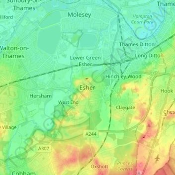
Name: Topografische Karte Esher, Höhe, Relief.
Ort: Esher, Elmbridge, Surrey, England, KT10 9QU, United Kingdom (51.32939 -0.40542 51.40939 -0.32542)
Durchschnittliche Höhe: 27 m
Minimale Höhe: -2 m
Maximale Höhe: 88 m
Esher is an outlying suburb of London near the London-Surrey Border, and with Esher Commons at its southern end, the town marks one limit of the Greater London Built-Up Area. Esher has a linear commercial high street and is otherwise suburban in density, with varying elevations, few high rise buildings and very short sections of dual carriageway within the ward itself. Esher covers a large area, between 13 and 15.4 miles southwest of Charing Cross. In the south it is bounded by the A3 Portsmouth Road which is of urban motorway standard and buffered by the Esher Commons.
Andere topografische Karten
Klicken Sie auf eine Karte, um ihre Topografie, ihre Höhe und ihr Relief anzuzeigen.
West End
United Kingdom > England > Surrey > Elmbridge
West End, Elmbridge, Surrey, England, KT10 8LY, United Kingdom
Durchschnittliche Höhe: 24 m
Cobham
United Kingdom > England > Surrey > Elmbridge
Cobham, Elmbridge, Surrey, England, United Kingdom
Durchschnittliche Höhe: 28 m