
Topografische Karte Cumberland
Interaktive Karte
Klicken Sie auf die Karte, um die Höhe anzuzeigen.
Über diese Karte
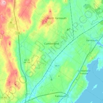
Name: Topografische Karte Cumberland, Höhe, Relief.
Ort: Cumberland, Cumberland County, Maine, United States (43.72405 -70.33678 43.84878 -70.15515)
Durchschnittliche Höhe: 51 m
Minimale Höhe: -1 m
Maximale Höhe: 172 m
Andere topografische Karten
Klicken Sie auf eine Karte, um ihre Topografie, ihre Höhe und ihr Relief anzuzeigen.
South Portland
United States > Maine > Cumberland County
South Portland, Cumberland County, Maine, 04106, United States
Durchschnittliche Höhe: 9 m
Sebascodegan Island
United States > Maine > Cumberland County > Harpswell
Sebascodegan Island, Harpswell, Cumberland County, Maine, 04079, United States
Durchschnittliche Höhe: 8 m
Little Sebago Lake
United States > Maine > Cumberland County > Gray
Little Sebago Lake, Gray, Cumberland County, Maine, 04039, United States
Durchschnittliche Höhe: 108 m
Pownal
United States > Maine > Cumberland County
Pownal, Cumberland County, Maine, 04069, United States
Durchschnittliche Höhe: 54 m
Harpswell
United States > Maine > Cumberland County
Harpswell, Cumberland County, Maine, 04079, United States
Durchschnittliche Höhe: 5 m
Brunswick
United States > Maine > Cumberland County
Brunswick, Cumberland County, Maine, 04011, United States
Durchschnittliche Höhe: 24 m
Crescent Beach
United States > Maine > Cumberland County > Cape Elizabeth
Crescent Beach, Cape Elizabeth, Cumberland County, Maine, 04107, United States
Durchschnittliche Höhe: 6 m
Birch Island
United States > Maine > Cumberland County > Harpswell > Birch Island
Birch Island, Harpswell, Cumberland County, Maine, 04079, United States
Durchschnittliche Höhe: 3 m
Falmouth
United States > Maine > Cumberland County
Falmouth, Cumberland County, Maine, 04105, United States
Durchschnittliche Höhe: 29 m