
Spenden
Rüste dich für dein nächstes Abenteuer:
Als Amazon-Partner verdient diese Website an qualifizierten Käufen, ohne zusätzliche Kosten für Sie.
Topografische Karte Indian Springs
Klicken Sie auf die Karte, um die Höhe anzuzeigen.
Spenden
Rüste dich für dein nächstes Abenteuer:
Als Amazon-Partner verdient diese Website an qualifizierten Käufen, ohne zusätzliche Kosten für Sie.
Indian Springs
Terrain in the area is generally rugged with elevations between 600 and 1,900 feet (580 m) above sea level, the landscape being primarily wooded. The terrain here differs greatly from the neighboring Hagerstown Valley, where elevations average less than 650' and is characterized by fertile, gently rolling hills. While land for farming is not as readily available in the Springs area, orchards have been a source of local livelihood for centuries.
Spenden
Rüste dich für dein nächstes Abenteuer:
Als Amazon-Partner verdient diese Website an qualifizierten Käufen, ohne zusätzliche Kosten für Sie.
Über diese Karte
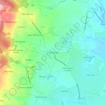
Name: Topografische Karte Indian Springs, Höhe, Relief.
Durchschnittliche Höhe: 143 m
Minimale Höhe: 94 m
Maximale Höhe: 266 m
Spenden
Rüste dich für dein nächstes Abenteuer:
Als Amazon-Partner verdient diese Website an qualifizierten Käufen, ohne zusätzliche Kosten für Sie.