
Topografische Karte Riebeek-Wes
Interaktive Karte
Klicken Sie auf die Karte, um die Höhe anzuzeigen.
Über diese Karte
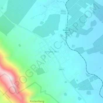
Name: Topografische Karte Riebeek-Wes, Höhe, Relief.
Durchschnittliche Höhe: 262 m
Minimale Höhe: 119 m
Maximale Höhe: 948 m
Andere topografische Karten
Klicken Sie auf eine Karte, um ihre Topografie, ihre Höhe und ihr Relief anzuzeigen.
Darling Wildflower Nature Reserve
South Africa > Western Cape > West Coast District Municipality > Swartland Local Municipality > Darling
Darling Wildflower Nature Reserve, R315, Nuwedorp, Swartland Ward 5, Darling, Swartland Local Municipality, West Coast District Municipality, Western Cape, South Africa
Durchschnittliche Höhe: 148 m
Koringberg
South Africa > Western Cape > West Coast District Municipality > Swartland Local Municipality
Koringberg, Swartland Local Municipality, West Coast District Municipality, Western Cape, South Africa
Durchschnittliche Höhe: 151 m
Malmesbury
South Africa > Western Cape > West Coast District Municipality > Swartland Local Municipality
Malmesbury, Swartland Local Municipality, West Coast District Municipality, Western Cape, 7300, South Africa
Durchschnittliche Höhe: 174 m
Darling
South Africa > Western Cape > West Coast District Municipality > Swartland Local Municipality
Darling, Swartland Local Municipality, West Coast District Municipality, Western Cape, South Africa
Durchschnittliche Höhe: 156 m
Yzerfontein
South Africa > Western Cape > West Coast District Municipality > Swartland Local Municipality
Yzerfontein, Swartland Local Municipality, West Coast District Municipality, Western Cape, 7351, South Africa
Durchschnittliche Höhe: 8 m
Riebeek-Kasteel
South Africa > Western Cape > West Coast District Municipality > Swartland Local Municipality
Riebeek-Kasteel, Swartland Local Municipality, West Coast District Municipality, Western Cape, 7307, South Africa
Durchschnittliche Höhe: 186 m
Malmesbury
South Africa > Western Cape > West Coast District Municipality > Swartland Local Municipality
Malmesbury, Swartland Local Municipality, West Coast District Municipality, Western Cape, South Africa
Durchschnittliche Höhe: 171 m
Moorreesburg
South Africa > Western Cape > West Coast District Municipality > Swartland Local Municipality
Moorreesburg, Swartland Local Municipality, West Coast District Municipality, Western Cape, South Africa
Durchschnittliche Höhe: 172 m