
Topografische Karte Lake Arlington
Interaktive Karte
Klicken Sie auf die Karte, um die Höhe anzuzeigen.
Über diese Karte
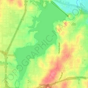
Name: Topografische Karte Lake Arlington, Höhe, Relief.
Durchschnittliche Höhe: 179 m
Minimale Höhe: 148 m
Maximale Höhe: 214 m
Andere topografische Karten
Klicken Sie auf eine Karte, um ihre Topografie, ihre Höhe und ihr Relief anzuzeigen.
Johnson creek
United States > Texas > Tarrant County > Arlington
Johnson creek, Arlington, Tarrant County, Texas, 76015, United States
Durchschnittliche Höhe: 198 m
La Frontera
United States > Texas > Tarrant County > Arlington > La Frontera
La Frontera, Arlington, Tarrant County, Texas, 76002, United States
Durchschnittliche Höhe: 185 m