
Topografische Karte Riggins
Interaktive Karte
Klicken Sie auf die Karte, um die Höhe anzuzeigen.
Über diese Karte
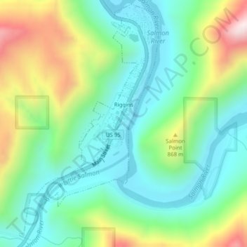
Name: Topografische Karte Riggins, Höhe, Relief.
Ort: Riggins, Idaho County, Idaho, 83549, United States (45.40719 -116.33166 45.43308 -116.31000)
Durchschnittliche Höhe: 706 m
Minimale Höhe: 509 m
Maximale Höhe: 1.144 m
Riggins is a city in the western United States in Idaho County, Idaho. Nestled deep in a canyon at the confluence of the Salmon and Little Salmon rivers in west central Idaho, it is approximately 150 highway miles (240 km) north of Boise, and 120 highway miles (190 km) south-southeast of Lewiston. The elevation is 1,821 feet (555 m) above sea level, and its population was 419 at the 2010 census.
Andere topografische Karten
Klicken Sie auf eine Karte, um ihre Topografie, ihre Höhe und ihr Relief anzuzeigen.
Nugget Point
United States > Idaho > Idaho County
Nugget Point, Idaho County, Idaho, United States
Durchschnittliche Höhe: 1.659 m
Grangeville
United States > Idaho > Idaho County
Grangeville, Idaho County, Idaho, United States
Durchschnittliche Höhe: 1.037 m
The Maze
United States > Idaho > Idaho County
The Maze, Idaho County, Idaho, United States
Durchschnittliche Höhe: 533 m
Dry Can Creek
United States > Idaho > Idaho County
Dry Can Creek, Idaho County, Idaho, United States
Durchschnittliche Höhe: 1.163 m