
Topografische Karte Estes Park
Interaktive Karte
Klicken Sie auf die Karte, um die Höhe anzuzeigen.
Über diese Karte
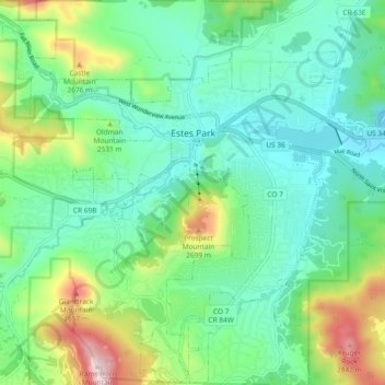
Name: Topografische Karte Estes Park, Höhe, Relief.
Ort: Estes Park, Larimer County, Colorado, 80517, United States (40.33115 -105.57946 40.40140 -105.48683)
Durchschnittliche Höhe: 2.430 m
Minimale Höhe: 2.258 m
Maximale Höhe: 2.897 m
Estes Park sits at an elevation of 7,522 feet (2,293 m) on the front range of the Rocky Mountains at the eastern entrance of the Rocky Mountain National Park. Its north, south and east extremities border the Roosevelt National Forest. Lumpy Ridge lies immediately north of Estes Park.
Andere topografische Karten
Klicken Sie auf eine Karte, um ihre Topografie, ihre Höhe und ihr Relief anzuzeigen.
Timnath
United States > Colorado > Larimer County
Timnath, Larimer County, Colorado, 80547, United States
Durchschnittliche Höhe: 1.493 m
Estes Park
United States > Colorado > Larimer County
Estes Park, Larimer County, Colorado, United States
Durchschnittliche Höhe: 2.409 m
Mount Evelyn
United States > Colorado > Larimer County
Mount Evelyn, Larimer County, Colorado, United States
Durchschnittliche Höhe: 2.206 m
Fort Collins
United States > Colorado > Larimer County
Fort Collins, Larimer County, Colorado, United States
Durchschnittliche Höhe: 1.548 m