
Topografische Karte Hollingsworth Bluff
Interaktive Karte
Klicken Sie auf die Karte, um die Höhe anzuzeigen.
Über diese Karte
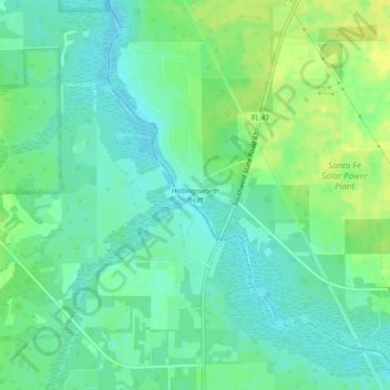
Name: Topografische Karte Hollingsworth Bluff, Höhe, Relief.
Ort: Hollingsworth Bluff, Columbia County, Florida, United States (29.84951 -82.76289 29.88951 -82.72289)
Durchschnittliche Höhe: 14 m
Minimale Höhe: 6 m
Maximale Höhe: 23 m
Andere topografische Karten
Klicken Sie auf eine Karte, um ihre Topografie, ihre Höhe und ihr Relief anzuzeigen.
Fort White
United States > Florida > Columbia County
Fort White, Columbia County, Florida, 32038, United States
Durchschnittliche Höhe: 22 m
Lake City
United States > Florida > Columbia County > Lake CIty
Lake City, Columbia County, Florida, 32026, United States
Durchschnittliche Höhe: 48 m
Lake CIty
United States > Florida > Columbia County > Lake CIty
Lake CIty, Columbia County, Florida, United States
Durchschnittliche Höhe: 48 m
Five Points
United States > Florida > Columbia County > Lake CIty
Five Points, Lake CIty, Columbia County, Florida, United States
Durchschnittliche Höhe: 50 m
Lake City
United States > Florida > Columbia County
Lake City, Columbia County, Florida, United States
Durchschnittliche Höhe: 48 m