
Topografische Karte Javier
Interaktive Karte
Klicken Sie auf die Karte, um die Höhe anzuzeigen.
Über diese Karte
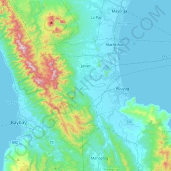
Name: Topografische Karte Javier, Höhe, Relief.
Durchschnittliche Höhe: 170 m
Minimale Höhe: -2 m
Maximale Höhe: 1.137 m
Andere topografische Karten
Klicken Sie auf eine Karte, um ihre Topografie, ihre Höhe und ihr Relief anzuzeigen.
MacArthur
MacArthur, Leyte 2nd District, Leyte, Eastern Visayas, 6509, Philippines
Durchschnittliche Höhe: 110 m
Colisao
Philippines > Leyte > Ormoc
Colisao, Ormoc, Leyte 4th District, Leyte, Eastern Visayas, 6541, Philippines
Durchschnittliche Höhe: 24 m
Lima
Philippines > Leyte > Pastrana > Lima
Lima, Pastrana, Leyte 2nd District, Leyte, Eastern Visayas, 6514, Philippines
Durchschnittliche Höhe: 36 m
MacArthur
Philippines > Leyte > MacArthur > MacArthur
MacArthur, Leyte 2nd District, Leyte, Eastern Visayas, 6509, Philippines
Durchschnittliche Höhe: 6 m
Tabango
Philippines > Leyte > Tabango
Tabango, Leyte 3rd District, Leyte, Eastern Visayas, 6536, Philippines
Durchschnittliche Höhe: 33 m
Tacloban
Philippines > Leyte > Tacloban
Tacloban, Leyte, Eastern Visayas, 6500, Philippines
Durchschnittliche Höhe: 29 m
Dulag
Philippines > Leyte > Dulag
Dulag, Leyte 2nd District, Leyte, Eastern Visayas, 6505, Philippines
Durchschnittliche Höhe: 3 m
Biasong
Philippines > Leyte > Biasong
Biasong, Baybay, Leyte 5th District, Leyte, Eastern Visayas, 6521, Philippines
Durchschnittliche Höhe: 29 m