
Topografische Karte Evinos
Interaktive Karte
Klicken Sie auf die Karte, um die Höhe anzuzeigen.
Über diese Karte
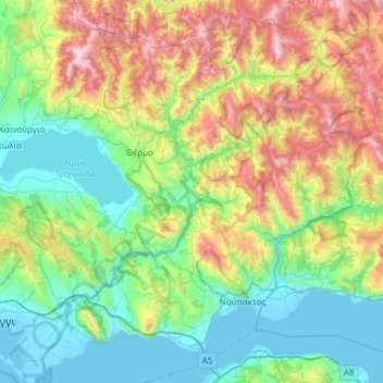
Name: Topografische Karte Evinos, Höhe, Relief.
Durchschnittliche Höhe: 539 m
Minimale Höhe: -4 m
Maximale Höhe: 1.910 m
Andere topografische Karten
Klicken Sie auf eine Karte, um ihre Topografie, ihre Höhe und ihr Relief anzuzeigen.
Patras
Griechenland > Peloponnes, Westgriechenland und Ionische Inseln > Regionalbezirk Achaia
Patras, Regionalbezirk Achaia, Region Westgriechenland, Peloponnes, Westgriechenland und Ionische Inseln, Griechenland
Durchschnittliche Höhe: 291 m
Kalavros
Griechenland > Peloponnes, Westgriechenland und Ionische Inseln > Regionalbezirk Lefkada > Δημοτική Ενότητα Λευκάδος
Kalavros, Δημοτική Ενότητα Λευκάδος, Δήμος Λευκάδας, Regionalbezirk Lefkada, Region der Ionischen Inseln, Peloponnes, Westgriechenland und Ionische Inseln, 311 00, Griechenland
Durchschnittliche Höhe: 224 m
Korfu
Griechenland > Peloponnes, Westgriechenland und Ionische Inseln > Regionalbezirk Korfu
Korfu, Δήμος Κεντρικής Κέρκυρας και Διαποντίων Νήσων, Regionalbezirk Korfu, Region der Ionischen Inseln, Peloponnes, Westgriechenland und Ionische Inseln, 491 00, Griechenland
Durchschnittliche Höhe: 67 m
Korfu
Griechenland > Peloponnes, Westgriechenland und Ionische Inseln > Korfu
Korfu, Δήμος Κέρκυρας, Regionalbezirk Korfu, Region der Ionischen Inseln, Peloponnes, Westgriechenland und Ionische Inseln, 49100, Griechenland
Durchschnittliche Höhe: 41 m
Kremasta-Stausee
Griechenland > Peloponnes, Westgriechenland und Ionische Inseln > Τρίκλινο
Kremasta-Stausee, Γέφυρα Βέργας - Δυτική Φραγκίστα, Κοινότητα Τρίκλινου, Τρίκλινο, Δήμος Αμφιλοχίας, Regionalbezirk Ätolien-Akarnanien, Region Westgriechenland, Peloponnes, Westgriechenland und Ionische Inseln, 30017, Griechenland
Durchschnittliche Höhe: 519 m
Stratos-Stausee
Griechenland > Peloponnes, Westgriechenland und Ionische Inseln > Αλώνια
Stratos-Stausee, Καλύβια - Γεφ. Σπολάιτας, Παλιάμπελα, Κοινότητα Σπολάιτας, Αλώνια, Δήμος Αγρινίου, Regionalbezirk Ätolien-Akarnanien, Region Westgriechenland, Peloponnes, Westgriechenland und Ionische Inseln, Griechenland
Durchschnittliche Höhe: 138 m
Kastraki-Stausee
Griechenland > Peloponnes, Westgriechenland und Ionische Inseln > Νέο Γιαννόπουλο
Kastraki-Stausee, Στράτος - Πατιόπουλο, Κοινότητα Μπαμπαλιού, Νέο Γιαννόπουλο, Δήμος Αμφιλοχίας, Regionalbezirk Ätolien-Akarnanien, Region Westgriechenland, Peloponnes, Westgriechenland und Ionische Inseln, 30018, Griechenland
Durchschnittliche Höhe: 309 m
Peloponnes, Westgriechenland und Ionische Inseln
Griechenland > Peloponnes, Westgriechenland und Ionische Inseln
Peloponnes, Westgriechenland und Ionische Inseln, Griechenland
Durchschnittliche Höhe: 215 m