
Topografische Karte El Encanto
Interaktive Karte
Klicken Sie auf die Karte, um die Höhe anzuzeigen.
Über diese Karte
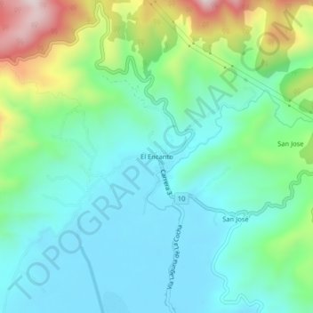
Name: Topografische Karte El Encanto, Höhe, Relief.
Ort: El Encanto, Pasto, Centro, Nariño, RAP Pacífico, Colombia (1.14269 -77.17631 1.18269 -77.13631)
Durchschnittliche Höhe: 2.919 m
Minimale Höhe: 2.779 m
Maximale Höhe: 3.317 m
Andere topografische Karten
Klicken Sie auf eine Karte, um ihre Topografie, ihre Höhe und ihr Relief anzuzeigen.
Isla de la Corota
Isla de la Corota, Pasto, Centro, Nariño, Colombia
Durchschnittliche Höhe: 2.786 m
Perímetro Urbano Pasto
Perímetro Urbano Pasto, Pasto, Centro, Nariño, RAP Pacífico, Colombia
Durchschnittliche Höhe: 2.676 m
Comuna 9
Colombia > Nariño > Pasto > Perímetro Urbano Pasto
Comuna 9, Perímetro Urbano Pasto, Pasto, Centro, Nariño, RAP Pacífico, Colombia
Durchschnittliche Höhe: 2.617 m