
Topografische Karte Riverwest
Interaktive Karte
Klicken Sie auf die Karte, um die Höhe anzuzeigen.
Riverwest
The Harambee community is just north of downtown Milwaukee and is bounded by Keefe Avenue to the north, Holton Street to the east, North Avenue to the south, and I-43 to the west. Harambee includes the highest residential elevation in the city, a tall ridge running along 1st Street. Between 1890 and 1910, well-to-do families built mansions on the North Side. Only a few are genuine mansions; the wealthiest Germans lived on the East and West Sides. Some are picturesque Queen Annes, with corner turrets and rambling floor plans. In 1984, the First Street corridor became an official historic district, listed on the National Register of Historic Places.
Über diese Karte
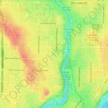
Name: Topografische Karte Riverwest, Höhe, Relief.
Ort: Riverwest, Milwaukee, Wisconsin, 53201, United States (43.05577 -87.90538 43.08924 -87.89243)
Durchschnittliche Höhe: 206 m
Minimale Höhe: 174 m
Maximale Höhe: 227 m