
Topografische Karte Carrieton
Interaktive Karte
Klicken Sie auf die Karte, um die Höhe anzuzeigen.
Über diese Karte
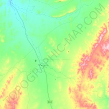
Name: Topografische Karte Carrieton, Höhe, Relief.
Durchschnittliche Höhe: 481 m
Minimale Höhe: 372 m
Maximale Höhe: 699 m
Andere topografische Karten
Klicken Sie auf eine Karte, um ihre Topografie, ihre Höhe und ihr Relief anzuzeigen.
Belton
Australia > South Australia > The District Council of Orroroo Carrieton
Belton, The District Council of Orroroo Carrieton, South Australia, 5432, Australia
Durchschnittliche Höhe: 512 m
Orroroo
Australia > South Australia > The District Council of Orroroo Carrieton > Orroroo
Orroroo, The District Council of Orroroo Carrieton, South Australia, 5431, Australia
Durchschnittliche Höhe: 447 m