
Topografische Karte Allagash River
Interaktive Karte
Klicken Sie auf die Karte, um die Höhe anzuzeigen.
Über diese Karte
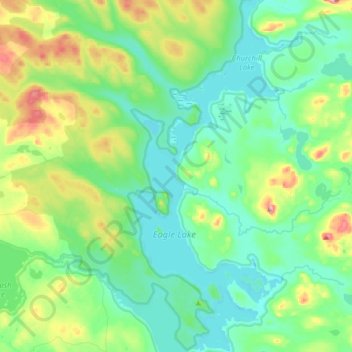
Name: Topografische Karte Allagash River, Höhe, Relief.
Durchschnittliche Höhe: 327 m
Minimale Höhe: 276 m
Maximale Höhe: 494 m
Andere topografische Karten
Klicken Sie auf eine Karte, um ihre Topografie, ihre Höhe und ihr Relief anzuzeigen.
St. Zacharie
États-Unis d'Amérique > Maine > Somerset County > T5 R20 WELS
St. Zacharie, T5 R20 WELS, Somerset County, Maine, États-Unis d'Amérique
Durchschnittliche Höhe: 540 m
Waterville
États-Unis d'Amérique > Maine > Kennebec County
Waterville, Kennebec County, Maine, États-Unis d'Amérique
Durchschnittliche Höhe: 54 m
Canaan
États-Unis d'Amérique > Maine > Somerset County
Canaan, Somerset County, Maine, 04924, États-Unis d'Amérique
Durchschnittliche Höhe: 100 m
Daaquam
États-Unis d'Amérique > Maine > Aroostook County
Daaquam, Powers Gore, Aroostook County, Maine, États-Unis d'Amérique
Durchschnittliche Höhe: 347 m
Islesboro
États-Unis d'Amérique > Maine > Waldo County
Islesboro, Waldo County, Maine, 04848, États-Unis d'Amérique
Durchschnittliche Höhe: 18 m
Franklin County
Franklin County, Maine, États-Unis d'Amérique
Durchschnittliche Höhe: 428 m
Rockland
États-Unis d'Amérique > Maine > Knox County > Rockland
Rockland, Knox County, Maine, 04841, États-Unis d'Amérique
Durchschnittliche Höhe: 37 m
Saint Aurelie
États-Unis d'Amérique > Maine > Somerset County
Saint Aurelie, Big Six Township, Somerset County, Maine, 04478, États-Unis d'Amérique
Durchschnittliche Höhe: 424 m
Owls Head
États-Unis d'Amérique > Maine > Knox County
Owls Head, Knox County, Maine, 04854, États-Unis d'Amérique
Durchschnittliche Höhe: 4 m
King Mountain
États-Unis d'Amérique > Maine > Franklin County
King Mountain, Franklin County, Maine, États-Unis d'Amérique
Durchschnittliche Höhe: 587 m
Owls Head
Owls Head, Somerset County, Maine, États-Unis d'Amérique
Durchschnittliche Höhe: 587 m
Augusta
États-Unis d'Amérique > Maine > Augusta
Augusta, Kennebec County, Maine, 04330, États-Unis d'Amérique
Durchschnittliche Höhe: 75 m
Popham Beach
États-Unis d'Amérique > Maine > Popham Beach
Popham Beach, Sagadahoc County, Maine, États-Unis d'Amérique
Durchschnittliche Höhe: 6 m
Rivière Saint-François
États-Unis d'Amérique > Maine > Aroostook County
Rivière Saint-François, T19 R11 WELS, Aroostook County, Maine, États-Unis d'Amérique
Durchschnittliche Höhe: 326 m
Rivière Saint-François
Rivière Saint-François, Aroostook County, Maine, J0L 1J0, États-Unis d'Amérique
Durchschnittliche Höhe: 326 m
Yellow Head
Yellow Head, Washington County, Maine, États-Unis d'Amérique
Durchschnittliche Höhe: 3 m
Bar Harbor
États-Unis d'Amérique > Maine > Bar Harbor
Bar Harbor, Hancock County, Maine, 04649, États-Unis d'Amérique
Durchschnittliche Höhe: 44 m
Oxford County
Oxford County, Maine, États-Unis d'Amérique
Durchschnittliche Höhe: 376 m
Carney Island
Carney Island, Hancock County, Maine, États-Unis d'Amérique
Durchschnittliche Höhe: 7 m
Gorham
États-Unis d'Amérique > Maine > Gorham
Gorham, Cumberland County, Maine, 04038, États-Unis d'Amérique
Durchschnittliche Höhe: 51 m
Somerset County
Somerset County, Maine, États-Unis d'Amérique
Durchschnittliche Höhe: 362 m
Gardiner
États-Unis d'Amérique > Maine > Kennebec County
Gardiner, Kennebec County, Maine, 04345, États-Unis d'Amérique
Durchschnittliche Höhe: 52 m
Burnt Mountain
Burnt Mountain, Piscataquis County, Maine, États-Unis d'Amérique
Durchschnittliche Höhe: 399 m
Mount Tom
Mount Tom, Washington County, Maine, États-Unis d'Amérique
Durchschnittliche Höhe: 57 m
Wayne
États-Unis d'Amérique > Maine > Wayne
Wayne, Kennebec County, Maine, 04284, États-Unis d'Amérique
Durchschnittliche Höhe: 97 m
Brooklin
États-Unis d'Amérique > Maine > Brooklin
Brooklin, Hancock County, Maine, 04616, États-Unis d'Amérique
Durchschnittliche Höhe: 16 m
York
États-Unis d'Amérique > Maine > York
York, York County, Maine, États-Unis d'Amérique
Durchschnittliche Höhe: 18 m
Washington County
Washington County, Maine, États-Unis d'Amérique
Durchschnittliche Höhe: 74 m
Center Island
Center Island, Piscataquis County, Maine, États-Unis d'Amérique
Durchschnittliche Höhe: 394 m
Mount Katahdin
Mount Katahdin, Piscataquis County, Maine, États-Unis d'Amérique
Durchschnittliche Höhe: 1.197 m