
Topografische Karte Goodland
Interaktive Karte
Klicken Sie auf die Karte, um die Höhe anzuzeigen.
Über diese Karte
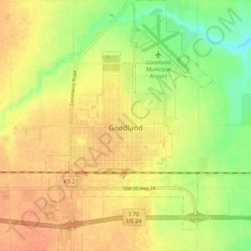
Name: Topografische Karte Goodland, Höhe, Relief.
Ort: Goodland, Sherman County, Kansas, 67735, United States (39.32218 -101.73418 39.38030 -101.68377)
Durchschnittliche Höhe: 1.120 m
Minimale Höhe: 1.097 m
Maximale Höhe: 1.134 m
Goodland is located at 39°21′3″N 101°42′37″W / 39.35083°N 101.71028°W / 39.35083; -101.71028 (39.3508330, −101.7101722) at an elevation of 3,681 feet (1,122 m). It lies on the south side of the Middle Fork of Sappa Creek, part of the Republican River watershed, in the High Plains region of the Great Plains. Located at the intersection of Interstate 70 and K-27 in northwest Kansas, Goodland is roughly 17 miles (27 km) east of the Colorado state line, 176 miles east-southeast of Denver, 265 miles (426 km) northwest of Wichita, and 383 miles (616 km) west of Kansas City.
Andere topografische Karten
Klicken Sie auf eine Karte, um ihre Topografie, ihre Höhe und ihr Relief anzuzeigen.
Kanorado
United States > Kansas > Sherman County
Kanorado, Sherman County, Kansas, United States
Durchschnittliche Höhe: 1.191 m