
Topografische Karte Osoyoos Lake
Klicken Sie auf die Karte, um die Höhe anzuzeigen.
Über diese Karte
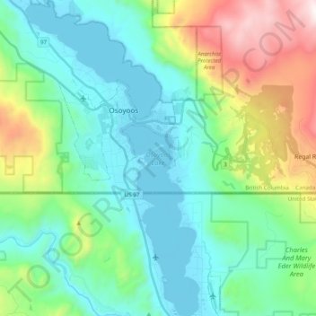
Name: Topografische Karte Osoyoos Lake, Höhe, Relief.
Durchschnittliche Höhe: 612 m
Minimale Höhe: 274 m
Maximale Höhe: 1.641 m
Andere topografische Karten
Klicken Sie auf eine Karte, um ihre Topografie, ihre Höhe und ihr Relief anzuzeigen.
Victoria
Canada > British Columbia > Capital Regional District > Victoria
Durchschnittliche Höhe: 47 m
Mill Bay
Canada > British Columbia > Cowichan Valley Regional District > Area A (Mill Bay / Malahat)
Durchschnittliche Höhe: 61 m
Stanley Park
Canada > British Columbia > Metro Vancouver Regional District > Vancouver
Durchschnittliche Höhe: 14 m
Elk River
Canada > British Columbia > Regional District of East Kootenay > Fernie
Durchschnittliche Höhe: 1.134 m
Green Timbers Urban Forest
Canada > British Columbia > Metro Vancouver Regional District > Surrey
Durchschnittliche Höhe: 100 m
Whistler
Canada > British Columbia > Squamish-Lillooet Regional District > Whistler Resort Municipality > Whistler
Durchschnittliche Höhe: 996 m
Britannia Beach
Canada > British Columbia > Squamish-Lillooet Regional District > Area D (Elaho/Garibaldi)
Durchschnittliche Höhe: 208 m
Klemtu
Canada > British Columbia > Regional District of Kitimat-Stikine > Area C (Butedale/Kitlope/Kitsumkalum)
Durchschnittliche Höhe: 152 m
Mount Robson
Canada > British Columbia > Regional District of Fraser-Fort George > Area H (Robson Valley/Canoe)
The north face can be seen from Berg Lake, and reached by a 19 km (11.8 mi) hike. The lake is approximately 2 km long and lies at 1,646 m (5,400 ft) elevation. There are backcountry campgrounds at each end of the lake and a log shelter on its banks, named Hargreaves Shelter in honor of the Hargreaves family…
Durchschnittliche Höhe: 3.037 m
Coquitlam
Canada > British Columbia > Metro Vancouver Regional District > Coquitlam
Southwest Coquitlam comprises the original core of the city, with Maillardville and Fraser River industrial sector giving way to the large residential areas of Austin Heights, colloquially referred to as "The Bump" due to its high and flat plateau topography. These older residences, with larger property…
Durchschnittliche Höhe: 230 m
Little River
Canada > British Columbia > Comox Valley Regional District > Area B (Lazo North)
Durchschnittliche Höhe: 13 m
Prince George
Canada > British Columbia > Regional District of Fraser-Fort George > Prince George
Durchschnittliche Höhe: 708 m
Grouse Mountain
Canada > British Columbia > Metro Vancouver Regional District
Grouse Mountain is one of the North Shore Mountains of the Pacific Ranges in the District Municipality of North Vancouver, British Columbia, Canada. With a maximum elevation of over 1,200 m (4,100 feet) at its peak, the mountain is the site of an alpine ski area, Grouse Mountain Resort, which overlooks Greater…
Durchschnittliche Höhe: 968 m
Eddy
Canada > British Columbia > Regional District of Fraser-Fort George > Area H (Robson Valley/Canoe)
Durchschnittliche Höhe: 729 m
Shawnigan Lake
Canada > British Columbia > Cowichan Valley Regional District > Area B (Shawnigan Lake)
Durchschnittliche Höhe: 128 m
Langley Township
Canada > British Columbia > Metro Vancouver Regional District > Township of Langley > Langley Township
Durchschnittliche Höhe: 37 m
Obo Lake
Canada > British Columbia > Peace River Regional District > Area B (Finlay Valley/Beatton Valley)
Durchschnittliche Höhe: 1.300 m
Errington
Canada > British Columbia > Regional District of Nanaimo > Area F (Alberni Highway)
Durchschnittliche Höhe: 120 m
Nanoose Bay
Canada > British Columbia > Regional District of Nanaimo > Area E (Nanoose Bay)
Durchschnittliche Höhe: 58 m
Fort Steele
Canada > British Columbia > Regional District of East Kootenay > Area C (Moyie/Bull River)
Durchschnittliche Höhe: 797 m
Dominic Lake
Canada > British Columbia > Thompson-Nicola Regional District > Area J (Copper Desert Country)
Durchschnittliche Höhe: 1.583 m
Spanish Banks Beach
Canada > British Columbia > University Endowment Lands
Durchschnittliche Höhe: 31 m
Salmon Arm
Canada > British Columbia > Columbia-Shuswap Regional District > Salmon Arm > Salmon Arm
Durchschnittliche Höhe: 479 m
Lower Nicola
Canada > British Columbia > Thompson-Nicola Regional District > Area M (Beautiful Nicola Valley - North)
Durchschnittliche Höhe: 649 m
Burton
Canada > British Columbia > Regional District of Central Kootenay > Area K (The Arrow Lakes)
Durchschnittliche Höhe: 578 m
Crescent Beach
Canada > British Columbia > Metro Vancouver Regional District > Surrey
Durchschnittliche Höhe: 22 m
Langdale
Canada > British Columbia > Sunshine Coast Regional District > Area F (West Howe Sound)
Durchschnittliche Höhe: 55 m
Nelway
Canada > British Columbia > Regional District of Central Kootenay > Area G (Salmo Valley)
Durchschnittliche Höhe: 924 m
Big Peters Lake
Canada > British Columbia > Regional District of North Okanagan > Area E (Cherryville/East Creighton)
Durchschnittliche Höhe: 1.850 m
Pavilion
The early anglicized version of the village name was Skwailuk, meaning hoar-frost, perhaps indicating the shaded ground remaining frozen during the long winters at this elevation. The Ts'kw'aylaxw First Nation (a.k.a. the Tsk'waylacw First Nation or Tsk'weylecw First Nation), residing on the Pavilion 1 Indian…
Durchschnittliche Höhe: 855 m
Anahim Lake
Canada > British Columbia > Cariboo Regional District > Area J (West Chilcotin)
Durchschnittliche Höhe: 1.101 m
Kamloops
Canada > British Columbia > Thompson-Nicola Regional District > Kamloops
Durchschnittliche Höhe: 875 m
5040 Peak
Canada > British Columbia > Alberni-Clayoquot Regional District > Area D (Sproat Lake)
Durchschnittliche Höhe: 1.092 m
Long Beach
Canada > British Columbia > Alberni-Clayoquot Regional District > Area C (Long Beach)
Durchschnittliche Höhe: 21 m
Oyster River
Canada > British Columbia > Strathcona Regional District > Area D (Oyster Bay/Buttle Lake) > Oyster River
Durchschnittliche Höhe: 24 m
Woodlot 0007
Canada > British Columbia > Metro Vancouver Regional District > Maple Ridge
Durchschnittliche Höhe: 322 m
Scotch Creek
Canada > British Columbia > Columbia-Shuswap Regional District > Area F (Scotch Creek/Seymour Arm)
Durchschnittliche Höhe: 1.125 m
Lake O'Hara
Canada > British Columbia > Columbia-Shuswap Regional District > Area A (Kicking Horse/Kinbasket Lake)
Lake O'Hara is a lake at an elevation of 2,020 metres (6,630 ft) in the alpine area of Yoho National Park, in the province of British Columbia, on the western side of the Great Divide with the province of Alberta and Banff National Park to the east. The lake and the valley are accessible through a bus service…
Durchschnittliche Höhe: 2.276 m
Fintry
Canada > British Columbia > Regional District of Central Okanagan > West Central Okanagan Electoral Area
Durchschnittliche Höhe: 437 m
Cedar
Canada > British Columbia > Regional District of Nanaimo > Area A (Cassidy/Cedar)
Durchschnittliche Höhe: 27 m
Anglemont
Canada > British Columbia > Columbia-Shuswap Regional District > Area F (Scotch Creek/Seymour Arm)
Durchschnittliche Höhe: 472 m
Cowichan Bay
Canada > British Columbia > Cowichan Valley Regional District > Area D (Cowichan Bay)
Durchschnittliche Höhe: 40 m
Bamfield
Canada > British Columbia > Alberni-Clayoquot Regional District > Area A (Bamfield)
Durchschnittliche Höhe: 16 m
Christian Valley
Canada > British Columbia > Regional District of Kootenay Boundary > Area E (Beaverdell/West Boundary)
Durchschnittliche Höhe: 917 m
Coast Mountains
Canada > British Columbia > Area A (Seymour Inlet/Knight Inlet)
The Coast Mountains are part of the Pacific Ring of Fire—the ring of volcanoes and associated mountains around the Pacific Ocean—and contain some of British Columbia's highest mountains. Mount Waddington is the highest mountain of the Coast Mountains and the highest that lies entirely within British…
Durchschnittliche Höhe: 1.951 m
Wasa Lake
Canada > British Columbia > Regional District of East Kootenay > Area E (Saint Mary/Skookumchuck) > Wasa
Durchschnittliche Höhe: 793 m
Joyce Lake
Canada > British Columbia > Columbia-Shuswap Regional District > Area D (Falkland/Silver Creek)
Durchschnittliche Höhe: 954 m
Rock Creek
Canada > British Columbia > Regional District of Kootenay Boundary > Area E (Beaverdell/West Boundary)
Durchschnittliche Höhe: 764 m
Sun Peaks
Canada > British Columbia > Thompson-Nicola Regional District > Sun Peaks Mountain Resort Municipality
Durchschnittliche Höhe: 1.490 m
Powerline Lake
Canada > British Columbia > Thompson-Nicola Regional District > Area L (Grasslands)
Durchschnittliche Höhe: 1.215 m
Trout Lake
Canada > British Columbia > Columbia-Shuswap Regional District > Area B (Shelter Bay/Mica Creek)
Durchschnittliche Höhe: 823 m
Rose Lake
Canada > British Columbia > Regional District of Bulkley-Nechako > Area B (Broman Lake/Sheraton)
Durchschnittliche Höhe: 775 m
The Black Tusk
Canada > British Columbia > Squamish-Lillooet Regional District > Area D (Elaho/Garibaldi)
Durchschnittliche Höhe: 1.874 m
Yew Lake
Canada > British Columbia > Metro Vancouver Regional District > West Vancouver
Durchschnittliche Höhe: 990 m
Monte Lake
Canada > British Columbia > Thompson-Nicola Regional District > Area L (Grasslands)
Durchschnittliche Höhe: 862 m
Eleanor Lake
Canada > British Columbia > Thompson-Nicola Regional District > Area B (Thompson Headwaters) > Blue River
Durchschnittliche Höhe: 695 m
Silver Star Mountain Resort
Canada > British Columbia > Regional District of North Okanagan > Area C (Silver Star)
Durchschnittliche Höhe: 1.584 m
Lax Kw'alaams
Canada > British Columbia > North Coast Regional District > Area A (North Skeena)
Durchschnittliche Höhe: 63 m
Triple Peak
Canada > British Columbia > Alberni-Clayoquot Regional District > Area C (Long Beach)
Durchschnittliche Höhe: 938 m
Kingsgate
Canada > British Columbia > Regional District of Central Kootenay > Area B (Goat River Valley)
Durchschnittliche Höhe: 979 m
70 Mile House
Canada > British Columbia > Thompson-Nicola Regional District > Area E (Bonaparte Plateau)
Durchschnittliche Höhe: 1.087 m
Falkland
Canada > British Columbia > Columbia-Shuswap Regional District > Area D (Falkland/Silver Creek)
Durchschnittliche Höhe: 786 m
Silvertip Mountain
Canada > British Columbia > Columbia-Shuswap Regional District > Area A (Kicking Horse/Kinbasket Lake)
Durchschnittliche Höhe: 2.443 m
Old Glory Mountain
Canada > British Columbia > Regional District of Kootenay Boundary > Area B (Lower Columbia/Old Glory)
Durchschnittliche Höhe: 1.953 m
Paterson
Canada > British Columbia > Regional District of Kootenay Boundary > Area B (Lower Columbia/Old Glory)
Durchschnittliche Höhe: 890 m
Rockslide Lake
Canada > British Columbia > Regional District of Central Kootenay > Area F (Kokanee Range)
Durchschnittliche Höhe: 1.605 m
Gibson Creek
Canada > British Columbia > Regional District of Central Kootenay > Area I (Sentinel Mountain)
Durchschnittliche Höhe: 778 m
Crawford Bay
Canada > British Columbia > Regional District of Central Kootenay > Area A (Wynndel/Crawford Bay/Riondel)
Durchschnittliche Höhe: 667 m