
Spenden
Rüste dich für dein nächstes Abenteuer:
Als Amazon-Partner verdient diese Website an qualifizierten Käufen, ohne zusätzliche Kosten für Sie.
Topografische Karte Cass County
Klicken Sie auf die Karte, um die Höhe anzuzeigen.
Spenden
Rüste dich für dein nächstes Abenteuer:
Als Amazon-Partner verdient diese Website an qualifizierten Käufen, ohne zusätzliche Kosten für Sie.
Über diese Karte
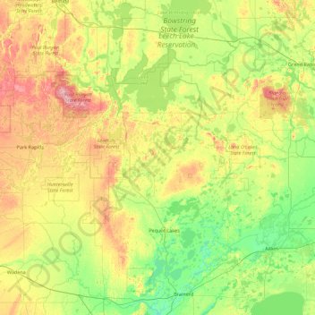
Name: Topografische Karte Cass County, Höhe, Relief.
Ort: Cass County, Minnesota, United States (46.27662 -94.78713 47.48074 -93.77384)
Durchschnittliche Höhe: 408 m
Minimale Höhe: 350 m
Maximale Höhe: 548 m
Spenden
Rüste dich für dein nächstes Abenteuer:
Als Amazon-Partner verdient diese Website an qualifizierten Käufen, ohne zusätzliche Kosten für Sie.
Andere topografische Karten
Klicken Sie auf eine Karte, um ihre Topografie, ihre Höhe und ihr Relief anzuzeigen.
Moody Lake
United States > Minnesota > Chisago County > Chisago Lake Township
Durchschnittliche Höhe: 283 m
Fort Snelling State Park
United States > Minnesota > Dakota County > Eagan
Durchschnittliche Höhe: 246 m
Spenden
Rüste dich für dein nächstes Abenteuer:
Als Amazon-Partner verdient diese Website an qualifizierten Käufen, ohne zusätzliche Kosten für Sie.
Elm Creek Park (Maple Grove Arboretum)
United States > Minnesota > Hennepin County > Maple Grove
Durchschnittliche Höhe: 278 m
Echo River
United States > Minnesota > Saint Louis County > Northeast St Louis
Durchschnittliche Höhe: 393 m
Borden Lake
United States > Minnesota > Crow Wing County > Garrison Township
Durchschnittliche Höhe: 393 m
Spenden
Rüste dich für dein nächstes Abenteuer:
Als Amazon-Partner verdient diese Website an qualifizierten Käufen, ohne zusätzliche Kosten für Sie.
Spenden
Rüste dich für dein nächstes Abenteuer:
Als Amazon-Partner verdient diese Website an qualifizierten Käufen, ohne zusätzliche Kosten für Sie.
Rum River North County Park
United States > Minnesota > Anoka County > Saint Francis
Durchschnittliche Höhe: 279 m
Spenden
Rüste dich für dein nächstes Abenteuer:
Als Amazon-Partner verdient diese Website an qualifizierten Käufen, ohne zusätzliche Kosten für Sie.
Central Lakes
United States > Minnesota > Saint Louis County > Ellsburg Township
Durchschnittliche Höhe: 408 m
Spencer Lake
United States > Minnesota > Meeker County > Collinwood Township > Jennie
Durchschnittliche Höhe: 334 m
Spenden
Rüste dich für dein nächstes Abenteuer:
Als Amazon-Partner verdient diese Website an qualifizierten Käufen, ohne zusätzliche Kosten für Sie.
Middle Cullen Lake
United States > Minnesota > Crow Wing County > Pequot Lakes
Durchschnittliche Höhe: 372 m
Mississippi River
United States > Minnesota > Hennepin County > Minneapolis
The uppermost lock and dam on the Upper Mississippi River is the Upper St. Anthony Falls Lock and Dam in Minneapolis. Above the dam, the river's elevation is 799 feet (244 m). Below the dam, the river's elevation is 750 feet (230 m). This 49-foot (15 m) drop is the largest of all the Mississippi River locks…
Durchschnittliche Höhe: 256 m
Spenden
Rüste dich für dein nächstes Abenteuer:
Als Amazon-Partner verdient diese Website an qualifizierten Käufen, ohne zusätzliche Kosten für Sie.
Little Rock Lake
United States > Minnesota > Benton County > Watab Township
Durchschnittliche Höhe: 322 m
Badger Ridge Park
United States > Minnesota > Olmsted County > Rochester
Durchschnittliche Höhe: 329 m
Spenden
Rüste dich für dein nächstes Abenteuer:
Als Amazon-Partner verdient diese Website an qualifizierten Käufen, ohne zusätzliche Kosten für Sie.
St. Croix River Boom Site Landing
United States > Minnesota > Washington County > Stillwater Township
Durchschnittliche Höhe: 253 m
Big Pine Lake
United States > Minnesota > Pine County > Pine Lake Township
Durchschnittliche Höhe: 339 m
Spenden
Rüste dich für dein nächstes Abenteuer:
Als Amazon-Partner verdient diese Website an qualifizierten Käufen, ohne zusätzliche Kosten für Sie.
Pearl Lake
United States > Minnesota > Stearns County > Maine Prairie Township
Durchschnittliche Höhe: 343 m
Spenden
Rüste dich für dein nächstes Abenteuer:
Als Amazon-Partner verdient diese Website an qualifizierten Käufen, ohne zusätzliche Kosten für Sie.
Countryside Mobile Home Park
United States > Minnesota > Pennington County > Thief River Falls
Durchschnittliche Höhe: 344 m
Spenden
Rüste dich für dein nächstes Abenteuer:
Als Amazon-Partner verdient diese Website an qualifizierten Käufen, ohne zusätzliche Kosten für Sie.
Chris Lake
United States > Minnesota > Saint Louis County > Pequaywan Township
Durchschnittliche Höhe: 494 m
Spenden
Rüste dich für dein nächstes Abenteuer:
Als Amazon-Partner verdient diese Website an qualifizierten Käufen, ohne zusätzliche Kosten für Sie.
Embarrass
United States > Minnesota > Saint Louis County > Embarrass Township
Durchschnittliche Höhe: 438 m
Spenden
Rüste dich für dein nächstes Abenteuer:
Als Amazon-Partner verdient diese Website an qualifizierten Käufen, ohne zusätzliche Kosten für Sie.
Spenden
Rüste dich für dein nächstes Abenteuer:
Als Amazon-Partner verdient diese Website an qualifizierten Käufen, ohne zusätzliche Kosten für Sie.
Ancient River Warren Channel (historical)
United States > Minnesota > Traverse County
Durchschnittliche Höhe: 300 m
Ford Dam Scenic Overlook
United States > Minnesota > Ramsey County > Saint Paul
Durchschnittliche Höhe: 251 m
Spenden
Rüste dich für dein nächstes Abenteuer:
Als Amazon-Partner verdient diese Website an qualifizierten Käufen, ohne zusätzliche Kosten für Sie.
Spenden
Rüste dich für dein nächstes Abenteuer:
Als Amazon-Partner verdient diese Website an qualifizierten Käufen, ohne zusätzliche Kosten für Sie.
Valley View Park
United States > Minnesota > Dodge County > Dodge Center
Durchschnittliche Höhe: 384 m
Spenden
Rüste dich für dein nächstes Abenteuer:
Als Amazon-Partner verdient diese Website an qualifizierten Käufen, ohne zusätzliche Kosten für Sie.
Riverbend Estates
United States > Minnesota > Nicollet County > North Mankato
Durchschnittliche Höhe: 265 m
Spenden
Rüste dich für dein nächstes Abenteuer:
Als Amazon-Partner verdient diese Website an qualifizierten Käufen, ohne zusätzliche Kosten für Sie.
Spenden
Rüste dich für dein nächstes Abenteuer:
Als Amazon-Partner verdient diese Website an qualifizierten Käufen, ohne zusätzliche Kosten für Sie.
Sungold Heights Mobile Home Park
United States > Minnesota > Nobles County > Worthington
Durchschnittliche Höhe: 482 m
Spenden
Rüste dich für dein nächstes Abenteuer:
Als Amazon-Partner verdient diese Website an qualifizierten Käufen, ohne zusätzliche Kosten für Sie.
Spenden
Rüste dich für dein nächstes Abenteuer:
Als Amazon-Partner verdient diese Website an qualifizierten Käufen, ohne zusätzliche Kosten für Sie.
Spenden
Rüste dich für dein nächstes Abenteuer:
Als Amazon-Partner verdient diese Website an qualifizierten Käufen, ohne zusätzliche Kosten für Sie.
Grey Cloud Island
United States > Minnesota > Washington County > Grey Cloud Island Township
Durchschnittliche Höhe: 225 m
Spenden
Rüste dich für dein nächstes Abenteuer:
Als Amazon-Partner verdient diese Website an qualifizierten Käufen, ohne zusätzliche Kosten für Sie.
Spenden
Rüste dich für dein nächstes Abenteuer:
Als Amazon-Partner verdient diese Website an qualifizierten Käufen, ohne zusätzliche Kosten für Sie.
Gulf of Minneapolis
United States > Minnesota > Ramsey County > Saint Paul
Durchschnittliche Höhe: 230 m
Natalie Webb Familly Aquatic Center
United States > Minnesota > Dodge County > Dodge Center > Valley View Park
Durchschnittliche Höhe: 384 m
Spenden
Rüste dich für dein nächstes Abenteuer:
Als Amazon-Partner verdient diese Website an qualifizierten Käufen, ohne zusätzliche Kosten für Sie.
Otter Tail Lake
United States > Minnesota > Otter Tail County > Ottertail
Durchschnittliche Höhe: 406 m
Twin Pine Mobile Home Park
United States > Minnesota > Washington County > Hugo
Durchschnittliche Höhe: 282 m
Spenden
Rüste dich für dein nächstes Abenteuer:
Als Amazon-Partner verdient diese Website an qualifizierten Käufen, ohne zusätzliche Kosten für Sie.