
Topografische Karte Cass County
Interaktive Karte
Klicken Sie auf die Karte, um die Höhe anzuzeigen.
Über diese Karte
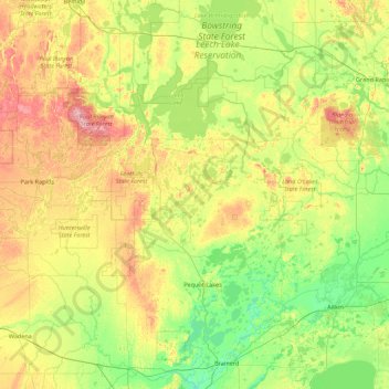
Name: Topografische Karte Cass County, Höhe, Relief.
Ort: Cass County, Minnesota, United States (46.27662 -94.78713 47.48074 -93.77384)
Durchschnittliche Höhe: 408 m
Minimale Höhe: 350 m
Maximale Höhe: 548 m
Andere topografische Karten
Klicken Sie auf eine Karte, um ihre Topografie, ihre Höhe und ihr Relief anzuzeigen.
Countryside Mobile Home Park
United States > Minnesota > Pennington County > Thief River Falls
Durchschnittliche Höhe: 344 m
Big Pine Lake
United States > Minnesota > Pine County > Pine Lake Township
Durchschnittliche Höhe: 339 m
Chris Lake
United States > Minnesota > Saint Louis County > Pequaywan Township
Durchschnittliche Höhe: 494 m
Mississippi River
United States > Minnesota > Hennepin County > Minneapolis
The uppermost lock and dam on the Upper Mississippi River is the Upper St. Anthony Falls Lock and Dam in Minneapolis. Above the dam, the river's elevation is 799 feet (244 m). Below the dam, the river's elevation is 750 feet (230 m). This 49-foot (15 m) drop is the largest of all the Mississippi River locks…
Durchschnittliche Höhe: 256 m
Ancient River Warren Channel (historical)
United States > Minnesota > Traverse County
Durchschnittliche Höhe: 300 m
Ford Dam Scenic Overlook
United States > Minnesota > Ramsey County > Saint Paul
Durchschnittliche Höhe: 251 m
Valley View Park
United States > Minnesota > Dodge County > Dodge Center
Durchschnittliche Höhe: 384 m
Riverbend Estates
United States > Minnesota > Nicollet County > North Mankato
Durchschnittliche Höhe: 265 m
Sungold Heights Mobile Home Park
United States > Minnesota > Nobles County > Worthington
Durchschnittliche Höhe: 482 m
Natalie Webb Familly Aquatic Center
United States > Minnesota > Dodge County > Dodge Center > Valley View Park
Durchschnittliche Höhe: 384 m
Gulf of Minneapolis
United States > Minnesota > Ramsey County > Saint Paul
Durchschnittliche Höhe: 230 m
Otter Tail Lake
United States > Minnesota > Otter Tail County > Ottertail
Durchschnittliche Höhe: 406 m
Twin Pine Mobile Home Park
United States > Minnesota > Washington County > Hugo
Durchschnittliche Höhe: 282 m
Eagle Mountain
United States > Minnesota > Cook County
Eagle Mountain is only about 15 miles (24 km) from Minnesota's lowest elevation, Lake Superior, at 600 feet (183 m). It is part of the Canadian Shield. Confusingly, there is another much shorter peak also named Eagle Mountain in northern Minnesota. The shorter peak is part of the Lutsen Mountains ski resort.
Durchschnittliche Höhe: 596 m
Silver Bay
United States > Minnesota > Lake County > Silver Bay > Silver Bay
Durchschnittliche Höhe: 256 m
Twin Lake Trails Mobile Home Park
United States > Minnesota > Itasca County
Durchschnittliche Höhe: 419 m
Eden Prairie
United States > Minnesota > Hennepin County > Eden Prairie > Eden Prairie
Durchschnittliche Höhe: 267 m