Geolokalisieren

Topografische Karte Tokat

Interaktive Karte

Klicken Sie auf die Karte, um die Höhe anzuzeigen.

Über diese Karte

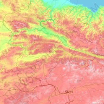
Name: Topografische Karte Tokat, Höhe, Relief.

Ort: Tokat, Black Sea Region, Turkey (39.86212 35.43958 40.91031 37.62246)

Durchschnittliche Höhe: 1.070 m

Minimale Höhe: 0 m

Maximale Höhe: 2.587 m

Andere topografische Karten

Klicken Sie auf eine Karte, um ihre Topografie, ihre Höhe und ihr Relief anzuzeigen.

Kartalkaya Kayak Merkezi

Turkey > Seben > Gerenözü Köyü

Durchschnittliche Höhe: 2.003 m

Tepe

Turkey > Lice

Durchschnittliche Höhe: 818 m

Bayat

Turkey > Gölpazarı

Durchschnittliche Höhe: 674 m

Cemre Parkı

Turkey > Yenimahalle

Durchschnittliche Höhe: 871 m

Toldam

Turkey > Felahiye > İsabey Mahallesi

Durchschnittliche Höhe: 1.392 m

Taşlıca

Turkey > Marmaris

Durchschnittliche Höhe: 233 m

Aşağı Yenice

Turkey > Dazkırı

Durchschnittliche Höhe: 863 m

Gölardı

Turkey > Gürpınar

Durchschnittliche Höhe: 2.400 m

Ören

Turkey > Milas

Durchschnittliche Höhe: 99 m

Kocaeli

Turkey > İzmit

Durchschnittliche Höhe: 289 m

Aşıküzeyir

Turkey > Posof

Durchschnittliche Höhe: 1.837 m

Topaklı

Turkey > Avanos

Durchschnittliche Höhe: 1.216 m

Gözpınar

Turkey > Efeler

Durchschnittliche Höhe: 577 m

Osmanpaşa

Turkey > Yozgat

Durchschnittliche Höhe: 1.061 m

Dodurga

Turkey > Seydikemer

Durchschnittliche Höhe: 602 m

Davulbaz

Turkey > Kangal

Durchschnittliche Höhe: 1.549 m

Saray

Turkey > Nizip

Durchschnittliche Höhe: 365 m

Hisarönü

Turkey > Digor

Durchschnittliche Höhe: 1.596 m

Ovit Dağı

Turkey > İkizdere

Durchschnittliche Höhe: 2.712 m

Maksut

Turkey > Azdavay

Durchschnittliche Höhe: 876 m

Kayaköy

Turkey > Fethiye

Durchschnittliche Höhe: 223 m

Baykal

Turkey > Çermik

Durchschnittliche Höhe: 875 m

Sapa

Turkey > Çorum

Durchschnittliche Höhe: 899 m

Gelinkaya

Turkey > Midyat

Durchschnittliche Höhe: 930 m

Pokut Yaylası

Turkey > Çamlıhemşin > Ortan

Durchschnittliche Höhe: 1.638 m

Mount Ararat

Turkey > Iğdır Merkez

Mount Ararat is a snow-capped and dormant compound volcano in the extreme east of Turkey. It consists of two major volcanic cones: Greater Ararat and Little Ararat. Greater Ararat is the highest peak in Turkey and the Armenian Highland with an elevation of 5,137 m (16,854 ft); Little Ararat's elevation is…

Durchschnittliche Höhe: 4.582 m

Pınarlı

Turkey > Şavşat

Durchschnittliche Höhe: 1.864 m

Tevfikiye

Turkey > Çanakkale Merkez

Durchschnittliche Höhe: 28 m

Karaağaç

Turkey > Çorum Merkez

Durchschnittliche Höhe: 1.224 m

Adana

Turkey > Seyhan

Heading west across Cilicia from Adana, the path to Tarsus crosses the foothills of the Taurus Mountains, eventually reaching an altitude of nearly 1,200 metres (4,000 ft) while passing through the Cilician Gates (Turkish: Gülek Boğazı), a rocky mountain pass functioning as the main artery to the Turkish…

Durchschnittliche Höhe: 61 m

Tokat

Turkey > Tokat > Tokat Merkez

Tokat has a hot-summer Mediterranean climate, or alternatively a continental climate (Köppen: Csa, Trewartha: Dc). Due to the relatively high altitude and inland location, winters are fairly cold with average lows below the freezing point and significant snowfall.

Durchschnittliche Höhe: 1.137 m

Heybeliada

Turkey > Prince Islands

Durchschnittliche Höhe: 11 m

Kenan

Turkey > Bismil > İsalı

Durchschnittliche Höhe: 562 m

Yeldeğirmeni

Turkey > Pınarbaşı

Durchschnittliche Höhe: 1.905 m

Oluközü

Turkey > Akdağmadeni

Durchschnittliche Höhe: 1.326 m

Satuk

Turkey > Yenice

Durchschnittliche Höhe: 422 m

Yoncabayırı

Turkey > İmranlı

Durchschnittliche Höhe: 1.696 m

Mount Erciyes

Turkey > Develi

The climate of the region is influenced by topography, with the Taurus and Kaçkar Mountains blocking the entry of moisture into Anatolia. Summers are dry and hot and winters wet and cold; in Kayseri, summer temperatures are about 19 °C (66 °F) and winter temperature about 0 °C (32 °F). Precipitation at…

Durchschnittliche Höhe: 3.329 m

Akdere

Turkey > Pamukkale

Durchschnittliche Höhe: 911 m

Atatürk Dam

Turkey > Bozova > Dutluca Mahallesi

Durchschnittliche Höhe: 525 m

Ĥuser Yaylası

Turkey > Çamlıhemşin

Durchschnittliche Höhe: 1.934 m

Avşaralanı

Turkey > Çayıralan

Durchschnittliche Höhe: 1.769 m

Turgutreis

Turkey > Bodrum

Durchschnittliche Höhe: 40 m

Altınpark

Turkey > Altındağ

Durchschnittliche Höhe: 889 m

Dokurcun

Turkey > Akyazı

Durchschnittliche Höhe: 482 m

Belen Cumafakılı

Turkey

Durchschnittliche Höhe: 1.377 m

Eskisehir

Turkey > Odunpazarı

Eskişehir has a cold semi-arid climate (BSk) under the Köppen climate classification, and a temperate continental climate (Dc) under the Trewartha climate classification. The city features cold, snowy winters and warm, dry summers. Rainfall occurs mostly during the spring and autumn. Due to Eskişehir's high…

Durchschnittliche Höhe: 949 m

Aktaş

Turkey > Amasya

Durchschnittliche Höhe: 1.397 m

Akçatarla

Turkey > Çarşamba

Durchschnittliche Höhe: 10 m

Dadağı

Turkey > Kocasinan

Durchschnittliche Höhe: 1.098 m

Erzincan

Turkey > Erzincan Merkez

Durchschnittliche Höhe: 1.702 m

Karabük

Turkey > Karabük Merkez

Durchschnittliche Höhe: 864 m

Kocaeli

Turkey > İzmit

Durchschnittliche Höhe: 293 m

Manisa

Turkey > Şehzadeler

Durchschnittliche Höhe: 253 m

Tunceli

Turkey > Tunceli Merkez

Durchschnittliche Höhe: 1.418 m

Yozgat

Turkey > Yozgat

Durchschnittliche Höhe: 1.250 m

Amasya

Turkey > Amasya Merkez

Durchschnittliche Höhe: 779 m

Aydin

Turkey > Efeler

Durchschnittliche Höhe: 363 m

Rize

Turkey > Rize Merkez

Durchschnittliche Höhe: 263 m

Osmaniye

Turkey > Osmaniye Merkez

Durchschnittliche Höhe: 441 m

Şehzadeler

Turkey > Şehzadeler

Durchschnittliche Höhe: 296 m

Madenli

Turkey > Çayeli

Durchschnittliche Höhe: 289 m

Sarhan

Turkey

Durchschnittliche Höhe: 1.729 m

Kızılcaova

Turkey > Akdağmadeni

Durchschnittliche Höhe: 1.960 m

Beyyurdu

Turkey > Beyyurdu

Durchschnittliche Höhe: 1.045 m

Ovakent

Turkey > Ödemiş > Ovakent

Durchschnittliche Höhe: 289 m

Uzunlu

Turkey > Uzunlu

Durchschnittliche Höhe: 14 m

Elçi

Turkey > Elçi

Durchschnittliche Höhe: 1.714 m

Ovaköy

Turkey > Ovaköy

Durchschnittliche Höhe: 383 m

Konya

Turkey > Selçuklu

Durchschnittliche Höhe: 1.160 m

Denizli

Turkey > Merkezefendi

Denizli is an industrial city in the southwestern part of Turkey and the eastern end of the alluvial valley formed by the river Büyük Menderes, where the plain reaches an elevation of about three hundred and fifty metres (1,148 ft). Denizli is located in the country's Aegean Region.

Durchschnittliche Höhe: 740 m

Benzer

Turkey > Central Anatolia Region > Benzer

Durchschnittliche Höhe: 1.023 m

Boncukgöze

Turkey > Eastern Anatolia Region > Boncukgöze

Durchschnittliche Höhe: 1.796 m

Gaziler

Turkey > Eastern Anatolia Region > Gaziler

Durchschnittliche Höhe: 1.909 m

Köyceğiz

Turkey > Eastern Anatolia Region > Köyceğiz

Durchschnittliche Höhe: 2.302 m

Tekirdağ

Turkey > Marmara Region > Tekirdağ > Süleymanpaşa

Durchschnittliche Höhe: 108 m

Edirne

Turkey > Edirne Merkez

Durchschnittliche Höhe: 92 m

Kayseri

Turkey > Melikgazi

Kayseri sits at the foot of Mount Erciyes (Turkish: Erciyes Dağı), a dormant volcano that reaches an altitude of 3,916 metres (12,848 feet), more than 1,500 metres above the city's mean altitude. It contains a number of historic monuments, particularly from the Seljuk period. Tourists often pass through…

Durchschnittliche Höhe: 1.345 m

Bolu

Turkey > Black Sea Region > Bolu

Durchschnittliche Höhe: 1.134 m

Alaşehir

Turkey > Aegean Region > Alaşehir

Durchschnittliche Höhe: 299 m

Kartepe

Turkey > Marmara Region > Kartepe

Durchschnittliche Höhe: 273 m

Sultaniye

Turkey > Marmara Region > Sultaniye

Durchschnittliche Höhe: 936 m

Erzurum

Turkey > Yakutiye

Durchschnittliche Höhe: 2.089 m

Antalya

Turkey > Muratpaşa

While the city itself only has modest elevation changes, Antalya has high mountains in all directions to its interior. With moisture being trapped, the local climate thus has high winter rainfall, while the interior bay setting result in very hot summers for a coastal city.

Durchschnittliche Höhe: 117 m

İnegöl

Turkey > İnegöl > İnegöl

Durchschnittliche Höhe: 306 m

Mandıra

Turkey > Marmara Region > Mandıra

Durchschnittliche Höhe: 304 m

Gebze

Turkey > Marmara Region > Gebze

Durchschnittliche Höhe: 120 m

Mardin

Turkey > Artuklu

Durchschnittliche Höhe: 848 m

Güzelsu

Turkey > Tomarza > Güzelsu

Durchschnittliche Höhe: 1.527 m

Yayalar

Turkey > Yayalar

Durchschnittliche Höhe: 2.164 m

Arıkçayırı

Turkey > Arıkçayırı

Durchschnittliche Höhe: 1.210 m

Hatay

Turkey > Hatay > Hatay

Durchschnittliche Höhe: 378 m

Kurutlutepe

Turkey > Şereflikoçhisar > Kurutlutepe

Durchschnittliche Höhe: 1.096 m

Karadağ Tepesi

Turkey > Trabzon > Vakfıkebir

Durchschnittliche Höhe: 1.698 m

Ertem

Turkey > Siverek > Ertem

Durchschnittliche Höhe: 777 m

Çaldere

Turkey > Silvan > Çaldere

Durchschnittliche Höhe: 1.130 m

Tortum

Turkey > Tortum > Tortum

Durchschnittliche Höhe: 1.820 m

Karıt

Turkey > Safranbolu > Karıt

Durchschnittliche Höhe: 430 m

Mersin

Turkey > Akdeniz

Durchschnittliche Höhe: 149 m

Sakarya

Turkey > Adapazarı

Durchschnittliche Höhe: 108 m