
Topografische Karte Tunnel Creek
Interaktive Karte
Klicken Sie auf die Karte, um die Höhe anzuzeigen.
Über diese Karte
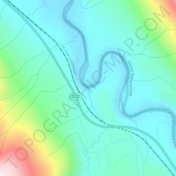
Name: Topografische Karte Tunnel Creek, Höhe, Relief.
Ort: Tunnel Creek, Flathead County, Montana, United States (48.37388 -113.67936 48.37410 -113.67930)
Durchschnittliche Höhe: 1.211 m
Minimale Höhe: 1.056 m
Maximale Höhe: 1.797 m
Andere topografische Karten
Klicken Sie auf eine Karte, um ihre Topografie, ihre Höhe und ihr Relief anzuzeigen.
Lake McDonald
United States > Montana > Flathead County
Lake McDonald, Flathead County, Montana, United States
Durchschnittliche Höhe: 1.209 m
Kalispell
United States > Montana > Flathead County
Kalispell, Flathead County, Montana, United States
Durchschnittliche Höhe: 934 m
West Glacier
United States > Montana > Flathead County > West Glacier
West Glacier, Flathead County, Montana, 59936, United States
Durchschnittliche Höhe: 1.201 m