
Topografische Karte Kalispell
Interaktive Karte
Klicken Sie auf die Karte, um die Höhe anzuzeigen.
Über diese Karte
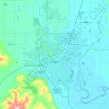
Name: Topografische Karte Kalispell, Höhe, Relief.
Ort: Kalispell, Flathead County, Montana, United States (48.13902 -114.37390 48.28449 -114.26881)
Durchschnittliche Höhe: 934 m
Minimale Höhe: 879 m
Maximale Höhe: 1.394 m
Kalispell is located at 48°11′52″N 114°18′58″W / 48.19778°N 114.31611°W / 48.19778; -114.31611 (48.197801, −114.316068), at an elevation of 2,956 feet (901 m).
Andere topografische Karten
Klicken Sie auf eine Karte, um ihre Topografie, ihre Höhe und ihr Relief anzuzeigen.
Tunnel Creek
United States > Montana > Flathead County
Tunnel Creek, Flathead County, Montana, United States
Durchschnittliche Höhe: 1.211 m
Lake McDonald
United States > Montana > Flathead County
Lake McDonald, Flathead County, Montana, United States
Durchschnittliche Höhe: 1.209 m
West Glacier
United States > Montana > Flathead County > West Glacier
West Glacier, Flathead County, Montana, 59936, United States
Durchschnittliche Höhe: 1.201 m