
Spenden
Rüste dich für dein nächstes Abenteuer:
Als Amazon-Partner verdient diese Website an qualifizierten Käufen, ohne zusätzliche Kosten für Sie.
Topografische Karte Cartago
Klicken Sie auf die Karte, um die Höhe anzuzeigen.
Spenden
Rüste dich für dein nächstes Abenteuer:
Als Amazon-Partner verdient diese Website an qualifizierten Käufen, ohne zusätzliche Kosten für Sie.
Cartago
Cartago (Spanish for "Carthage") is a census-designated place in Inyo County, California, United States. Cartago is located on the west side of Owens Lake 3 miles (4.8 km) north-northwest of Olancha, at an elevation of 3629 feet (1106 m). The population was 92 at the 2010 census, down from 109 at the 2000 census.
Spenden
Rüste dich für dein nächstes Abenteuer:
Als Amazon-Partner verdient diese Website an qualifizierten Käufen, ohne zusätzliche Kosten für Sie.
Über diese Karte
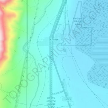
Name: Topografische Karte Cartago, Höhe, Relief.
Ort: Cartago, Inyo County, California, United States (36.29778 -118.03366 36.33396 -118.01820)
Durchschnittliche Höhe: 1.152 m
Minimale Höhe: 1.088 m
Maximale Höhe: 1.503 m
Spenden
Rüste dich für dein nächstes Abenteuer:
Als Amazon-Partner verdient diese Website an qualifizierten Käufen, ohne zusätzliche Kosten für Sie.
Andere topografische Karten
Klicken Sie auf eine Karte, um ihre Topografie, ihre Höhe und ihr Relief anzuzeigen.
Independence
United States > California > Inyo County
Independence is a census-designated place in Inyo County, California. Independence is located 41 miles (66 km) south-southeast of Bishop, at an elevation of 3930 feet (1198 m). It is the county seat of Inyo County, California. The population of this census-designated place was 669 at the 2010 census, up from…
Durchschnittliche Höhe: 1.210 m
Spenden
Rüste dich für dein nächstes Abenteuer:
Als Amazon-Partner verdient diese Website an qualifizierten Käufen, ohne zusätzliche Kosten für Sie.
Spenden
Rüste dich für dein nächstes Abenteuer:
Als Amazon-Partner verdient diese Website an qualifizierten Käufen, ohne zusätzliche Kosten für Sie.
Spenden
Rüste dich für dein nächstes Abenteuer:
Als Amazon-Partner verdient diese Website an qualifizierten Käufen, ohne zusätzliche Kosten für Sie.
Spenden
Rüste dich für dein nächstes Abenteuer:
Als Amazon-Partner verdient diese Website an qualifizierten Käufen, ohne zusätzliche Kosten für Sie.
Spenden
Rüste dich für dein nächstes Abenteuer:
Als Amazon-Partner verdient diese Website an qualifizierten Käufen, ohne zusätzliche Kosten für Sie.
Spenden
Rüste dich für dein nächstes Abenteuer:
Als Amazon-Partner verdient diese Website an qualifizierten Käufen, ohne zusätzliche Kosten für Sie.
Big Pine
United States > California > Inyo County
Big Pine (formerly Bigpine) is a census-designated place (CDP) in Inyo County, California, United States. Big Pine is located approximately 15 miles (24 km) south-southeast of Bishop, at an elevation of 3,989 feet (1,216 m). The population was 1,756 at the 2010 census, up from 1,350 at the 2000 census. The Big…
Durchschnittliche Höhe: 1.232 m
Charleston View
United States > California > Inyo County
Charleston View, formally known as Calvada Springs, is an unincorporated community in Inyo County, California. It lies at an elevation of 2621 feet (799 m). The Charleston View CDP had a population of 45 in the 2020 census
Durchschnittliche Höhe: 802 m
Spenden
Rüste dich für dein nächstes Abenteuer:
Als Amazon-Partner verdient diese Website an qualifizierten Käufen, ohne zusätzliche Kosten für Sie.
Round Valley
United States > California > Inyo County
Round Valley is a census-designated place (CDP) in Inyo County, California, United States. Round Valley is located 7.5 miles (12 km) northeast of Mount Tom, at an elevation of 4692 feet (1430 m). The population was 435 at the 2010 census, up from 278 at the 2000 census.
Durchschnittliche Höhe: 1.491 m
Spenden
Rüste dich für dein nächstes Abenteuer:
Als Amazon-Partner verdient diese Website an qualifizierten Käufen, ohne zusätzliche Kosten für Sie.
Alabama Hills
United States > California > Inyo County
Alabama Hills is an unincorporated community in the Alabama Hills, in Inyo County, California.[1] It lies at an elevation of 4534 feet (1382 m).[1] The community was named after the CSS Alabama.[2]
Durchschnittliche Höhe: 1.427 m
Spenden
Rüste dich für dein nächstes Abenteuer:
Als Amazon-Partner verdient diese Website an qualifizierten Käufen, ohne zusätzliche Kosten für Sie.
Dirty Socks Hot Spring
United States > California > Inyo County > Olancha
Durchschnittliche Höhe: 1.105 m
Spenden
Rüste dich für dein nächstes Abenteuer:
Als Amazon-Partner verdient diese Website an qualifizierten Käufen, ohne zusätzliche Kosten für Sie.
Spenden
Rüste dich für dein nächstes Abenteuer:
Als Amazon-Partner verdient diese Website an qualifizierten Käufen, ohne zusätzliche Kosten für Sie.