
Spenden
Rüste dich für dein nächstes Abenteuer:
Als Amazon-Partner verdient diese Website an qualifizierten Käufen, ohne zusätzliche Kosten für Sie.
Topografische Karte Alabama Hills
Klicken Sie auf die Karte, um die Höhe anzuzeigen.
Spenden
Rüste dich für dein nächstes Abenteuer:
Als Amazon-Partner verdient diese Website an qualifizierten Käufen, ohne zusätzliche Kosten für Sie.
Alabama Hills
Alabama Hills is an unincorporated community in the Alabama Hills, in Inyo County, California.[1] It lies at an elevation of 4534 feet (1382 m).[1] The community was named after the CSS Alabama.[2]
Spenden
Rüste dich für dein nächstes Abenteuer:
Als Amazon-Partner verdient diese Website an qualifizierten Käufen, ohne zusätzliche Kosten für Sie.
Über diese Karte
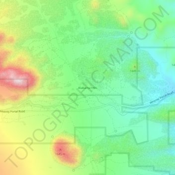
Name: Topografische Karte Alabama Hills, Höhe, Relief.
Ort: Alabama Hills, Inyo County, California, United States (36.57933 -118.13693 36.61933 -118.09693)
Durchschnittliche Höhe: 1.427 m
Minimale Höhe: 1.254 m
Maximale Höhe: 1.740 m
Spenden
Rüste dich für dein nächstes Abenteuer:
Als Amazon-Partner verdient diese Website an qualifizierten Käufen, ohne zusätzliche Kosten für Sie.
Andere topografische Karten
Klicken Sie auf eine Karte, um ihre Topografie, ihre Höhe und ihr Relief anzuzeigen.
Spenden
Rüste dich für dein nächstes Abenteuer:
Als Amazon-Partner verdient diese Website an qualifizierten Käufen, ohne zusätzliche Kosten für Sie.
Cartago
United States > California > Inyo County
Cartago (Spanish for "Carthage") is a census-designated place in Inyo County, California, United States. Cartago is located on the west side of Owens Lake 3 miles (4.8 km) north-northwest of Olancha, at an elevation of 3629 feet (1106 m). The population was 92 at the 2010 census, down from 109 at the 2000…
Durchschnittliche Höhe: 1.152 m
Darwin
United States > California > Inyo County
Darwin is an unincorporated mining community in Inyo County, California, United States. It is located 22 miles (35 km) southeast of Keeler, at an elevation of 4,790 ft (1,460 m). The population was 43 at the 2010 census, down from 54 at the 2000 census.
Durchschnittliche Höhe: 1.484 m
Spenden
Rüste dich für dein nächstes Abenteuer:
Als Amazon-Partner verdient diese Website an qualifizierten Käufen, ohne zusätzliche Kosten für Sie.
Round Valley
United States > California > Inyo County
Round Valley is a census-designated place (CDP) in Inyo County, California, United States. Round Valley is located 7.5 miles (12 km) northeast of Mount Tom, at an elevation of 4692 feet (1430 m). The population was 435 at the 2010 census, up from 278 at the 2000 census.
Durchschnittliche Höhe: 1.491 m
Olancha
United States > California > Inyo County
Olancha (Timbisha: Pakwa' si) is a census designated place in Inyo County of the U.S. state of California. Olancha is located on U.S. Route 395 in California, 37 miles (60 km) south-southeast of Independence, at an elevation of 3658 feet (1115 m). As of the 2010 census, the population was 192, up from 134 at…
Durchschnittliche Höhe: 1.200 m
Spenden
Rüste dich für dein nächstes Abenteuer:
Als Amazon-Partner verdient diese Website an qualifizierten Käufen, ohne zusätzliche Kosten für Sie.