
Topografische Karte Kodagu
Interaktive Karte
Klicken Sie auf die Karte, um die Höhe anzuzeigen.
Über diese Karte
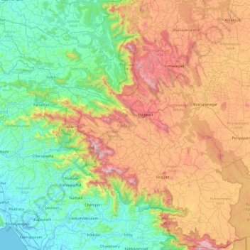
Name: Topografische Karte Kodagu, Höhe, Relief.
Ort: Kodagu, Karnataka, India (11.93123 75.36544 12.83349 76.18857)
Durchschnittliche Höhe: 561 m
Minimale Höhe: -3 m
Maximale Höhe: 1.713 m
Kodagu is located on the eastern slopes of the Western Ghats. It has a geographical area of 4,102 km2 (1,584 sq mi). The district is bordered by Dakshina Kannada district to the northwest, Hassan district to the north, Mysore district to the east, Kasaragod district in west and Kannur district of Kerala to the southwest, and Wayanad district of Kerala to the south. It is a hilly district, the lowest elevation of which is 120 metres (390 ft) above sea-level. The highest peak, Tadiandamol, rises to 1,750 metres (5,740 ft), with Pushpagiri, the second highest, at 1,715 metres (5,627 ft). The main river in Kodagu is the Kaveri (Cauvery), which originates at Talakaveri, located on the eastern side of the Western Ghats, and with its tributaries, drains the greater part of Kodagu.
Andere topografische Karten
Klicken Sie auf eine Karte, um ihre Topografie, ihre Höhe und ihr Relief anzuzeigen.
Bengaluru
India > Karnataka > Bangalore North
Bengaluru, Bangalore North, Bengaluru Urban, Karnataka, India
Durchschnittliche Höhe: 886 m
Bangalore South
Bangalore South, Bengaluru Urban, Karnataka, India
Durchschnittliche Höhe: 847 m
Hassan
India > Karnataka > Hasana taluk
Hassan, Hasana taluk, Hassan district, Karnataka, 573201, India
Durchschnittliche Höhe: 949 m
Bengaluru
India > Karnataka > Bangalore North > Bengaluru
Bengaluru, Bangalore North, Bangalore Urban, Karnataka, 560001, India
Durchschnittliche Höhe: 879 m
Vasana
India > Karnataka > Harihara taluku > Vasana
Vasana, Harihara taluku, Davanagere District, Karnataka, 581119, India
Durchschnittliche Höhe: 543 m
Garugadahalli
India > Karnataka > Garugadahalli
Garugadahalli, Kaduru taluk, Chikkamagaluru district, Karnataka, India
Durchschnittliche Höhe: 726 m
Kalaburagi
India > Karnataka > Kalaburagi
Kalaburagi, Gulbarga taluku, Kalaburagi district, Karnataka, 585101, India
Durchschnittliche Höhe: 465 m
Hadonahalli
India > Karnataka > Hadonahalli
Hadonahalli, Doddaballapura taluk, Bangalore Rural, Karnataka, India
Durchschnittliche Höhe: 913 m
Tadiandamol
Tadiandamol, Madikeri taluku, Kodagu, Karnataka, India
Durchschnittliche Höhe: 1.322 m
Baba Budangiri
India > Karnataka > Chikkamagaluru
Baba Budangiri, Chikkamagaluru, Chikkamagaluru taluku, Chikkamagaluru district, Karnataka, 577101, India
Durchschnittliche Höhe: 1.628 m
Kumara Parvatha
Kumara Parvatha, Somawarpet taluk, Kodagu, Karnataka, India
Durchschnittliche Höhe: 1.227 m
Krishna River
Krishna River, Shahapura taluku, Yadagiri district, Karnataka, 412803, India
Durchschnittliche Höhe: 413 m
Chikmagalur
Chikmagalur, Chikkamagaluru district, Karnataka, India
Durchschnittliche Höhe: 652 m
Hegganahalli
Hegganahalli, Dasarahalli Zone, Bengaluru, Bangalore Urban, Karnataka, India
Durchschnittliche Höhe: 907 m