
Topografische Karte Whitehorse
Interaktive Karte
Klicken Sie auf die Karte, um die Höhe anzuzeigen.
Über diese Karte
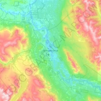
Name: Topografische Karte Whitehorse, Höhe, Relief.
Ort: Whitehorse, Yukon, Canada (60.56157 -135.21493 60.88157 -134.89493)
Durchschnittliche Höhe: 1.008 m
Minimale Höhe: 629 m
Maximale Höhe: 1.894 m
Whitehorse has a subarctic climate (Köppen climate classification: Dfc) and lies in the rain shadow of the Coast Mountains, causing precipitation totals to be quite low year-round. Due to the city's location in the Whitehorse valley, the climate is milder than other comparable northern communities such as Yellowknife, however during cold snaps it is not uncommon for temperatures to drop below −40 °C (−40 °F). With an average annual temperature of −0.1 °C (31.8 °F) Whitehorse is the warmest place in the Yukon. The temperature measurements for the city are taken at the airport. The Whitehorse Riverdale weather station situated at a lower elevation than the airport is even warmer at 0.2 °C (32.4 °F).
Andere topografische Karten
Klicken Sie auf eine Karte, um ihre Topografie, ihre Höhe und ihr Relief anzuzeigen.
Saint Elias Mountains
Saint Elias Mountains, Yukon, Canada
Durchschnittliche Höhe: 4.403 m
Kluane National Park and Reserve
Kluane National Park and Reserve, Yukon, Canada
Durchschnittliche Höhe: 1.536 m
Two Mile Village
Canada > Yukon > Watson Lake
Two Mile Village, Watson Lake, Yukon, Y0A 1C0, Canada
Durchschnittliche Höhe: 703 m
Destruction Bay
Canada > Yukon > Destruction Bay
Destruction Bay, Yukon, Y0B 1H0, Canada
Durchschnittliche Höhe: 893 m
Ivvavik National Park
Ivvavik National Park, Yukon, Canada
Durchschnittliche Höhe: 427 m
Dawson City
Canada > Yukon > Dawson City > Dawson City
Dawson City, Yukon, Y0B 1G0, Canada
Durchschnittliche Höhe: 510 m
Yukon, Unorganized
City of Whitehorse, Yukon, Unorganized, Yukon, Canada
Durchschnittliche Höhe: 1.010 m
Swift River
Canada > Yukon > Swift River
Swift River, Yukon, Unorganized, Yukon, Canada
Durchschnittliche Höhe: 1.086 m