
Spenden
Rüste dich für dein nächstes Abenteuer:
Als Amazon-Partner verdient diese Website an qualifizierten Käufen, ohne zusätzliche Kosten für Sie.
Topografische Karte Alt-Ossiach
Klicken Sie auf die Karte, um die Höhe anzuzeigen.
Spenden
Rüste dich für dein nächstes Abenteuer:
Als Amazon-Partner verdient diese Website an qualifizierten Käufen, ohne zusätzliche Kosten für Sie.
Über diese Karte
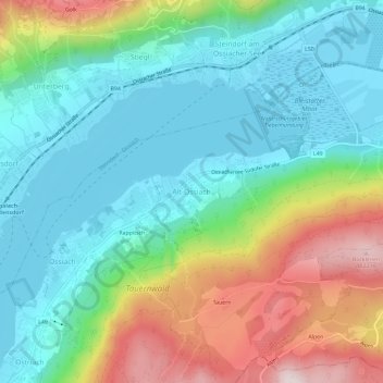
Name: Topografische Karte Alt-Ossiach, Höhe, Relief.
Durchschnittliche Höhe: 665 m
Minimale Höhe: 495 m
Maximale Höhe: 1.049 m
Spenden
Rüste dich für dein nächstes Abenteuer:
Als Amazon-Partner verdient diese Website an qualifizierten Käufen, ohne zusätzliche Kosten für Sie.
Andere topografische Karten
Klicken Sie auf eine Karte, um ihre Topografie, ihre Höhe und ihr Relief anzuzeigen.
Pasterze
Austria > Carinthia > Bezirk Spittal an der Drau > Heiligenblut am Großglockner
Durchschnittliche Höhe: 2.599 m
Spenden
Rüste dich für dein nächstes Abenteuer:
Als Amazon-Partner verdient diese Website an qualifizierten Käufen, ohne zusätzliche Kosten für Sie.
Millstatt am See
Austria > Carinthia > Bezirk Spittal an der Drau
It is situated on the southern slope of the Gurktal Alps (Nock Mountains), on an alluvial fan peninsula on the lake's northern shore. The municipal area reaches from an elevation of 588 m (1,929 ft) at the lakeside to 2,101 m (6,893 ft) AA at the crest of the Millstätter Alpe massif. It comprises the…
Durchschnittliche Höhe: 1.149 m
Spenden
Rüste dich für dein nächstes Abenteuer:
Als Amazon-Partner verdient diese Website an qualifizierten Käufen, ohne zusätzliche Kosten für Sie.
Lake Wörth
Austria > Carinthia > Bezirk Klagenfurt-Land > Schiefling am Wörthersee
Durchschnittliche Höhe: 619 m
Spenden
Rüste dich für dein nächstes Abenteuer:
Als Amazon-Partner verdient diese Website an qualifizierten Käufen, ohne zusätzliche Kosten für Sie.
Spenden
Rüste dich für dein nächstes Abenteuer:
Als Amazon-Partner verdient diese Website an qualifizierten Käufen, ohne zusätzliche Kosten für Sie.
Dellach
Austria > Carinthia > Bezirk Hermagor
The municipal area lies in the upper Gail valley, between the neighbouring municipalities of Kötschach-Mauthen in the west and Kirchbach in the east. The Carnic Alps in the south form the border with Paularo in Italy. In the north rises Mt. Reißkofel, the highest peak of the Gailtal Alps east of the Lienz…
Durchschnittliche Höhe: 1.233 m
Spenden
Rüste dich für dein nächstes Abenteuer:
Als Amazon-Partner verdient diese Website an qualifizierten Käufen, ohne zusätzliche Kosten für Sie.
Lake Faak
Austria > Carinthia > Bezirk Villach-Land > Finkenstein am Faaker See > Faak am See
Durchschnittliche Höhe: 572 m
Spenden
Rüste dich für dein nächstes Abenteuer:
Als Amazon-Partner verdient diese Website an qualifizierten Käufen, ohne zusätzliche Kosten für Sie.
Lake Pressegg
Austria > Carinthia > Bezirk Hermagor > Hermagor-Pressegger See > Presseggersee > Paßriach
Durchschnittliche Höhe: 627 m
Bad Kleinkirchheim
Austria > Carinthia > Bezirk Spittal an der Drau
Bad Kleinkirchheim is at an average elevation of 1,087 m (3,566 ft) in a 5 km (3 mi) stretch of a glacial trough valley in the Gurktal Alps (Nock Mountains), between the Millstätter See and the upper Gurk River. The populated section lies between 980 m (3,215 ft) and 1,380 m (4,528 ft), and the highest point…
Durchschnittliche Höhe: 1.605 m
Spenden
Rüste dich für dein nächstes Abenteuer:
Als Amazon-Partner verdient diese Website an qualifizierten Käufen, ohne zusätzliche Kosten für Sie.
Spenden
Rüste dich für dein nächstes Abenteuer:
Als Amazon-Partner verdient diese Website an qualifizierten Käufen, ohne zusätzliche Kosten für Sie.
Spenden
Rüste dich für dein nächstes Abenteuer:
Als Amazon-Partner verdient diese Website an qualifizierten Käufen, ohne zusätzliche Kosten für Sie.
Bad Kleinkirchheim
Austria > Carinthia > Bezirk Spittal an der Drau
Bad Kleinkirchheim is at an average elevation of 1,087 m (3,566 ft) in a 5 km (3 mi) stretch of a glacial trough valley in the Gurktal Alps (Nock Mountains), between the Millstätter See and the upper Gurk River. The populated section lies between 980 m (3,215 ft) and 1,380 m (4,528 ft), and the highest point…
Durchschnittliche Höhe: 1.605 m
Lavamünd
Austria > Carinthia > Bezirk Wolfsberg
Lavamünd lies in the southeast of Carinthia, close to the border with Slovenia (Slovene Carinthia). It is situated at the confluence of the Lavant and Drava rivers. In the northeast, the Soboth Pass leads across the Koralpe range to Eibiswald in Styria. At an elevation of 348 m (1,142 ft) AA, the area is the…
Durchschnittliche Höhe: 768 m
Heiligenblut am Großglockner
Austria > Carinthia > Bezirk Spittal an der Drau
Durchschnittliche Höhe: 2.236 m
Spenden
Rüste dich für dein nächstes Abenteuer:
Als Amazon-Partner verdient diese Website an qualifizierten Käufen, ohne zusätzliche Kosten für Sie.
Spenden
Rüste dich für dein nächstes Abenteuer:
Als Amazon-Partner verdient diese Website an qualifizierten Käufen, ohne zusätzliche Kosten für Sie.
High Tauern National Park
Austria > Carinthia > Bezirk Spittal an der Drau > Heiligenblut am Großglockner
Durchschnittliche Höhe: 1.710 m
Seeboden am Millstätter See
Austria > Carinthia > Bezirk Spittal an der Drau
Durchschnittliche Höhe: 942 m
Spenden
Rüste dich für dein nächstes Abenteuer:
Als Amazon-Partner verdient diese Website an qualifizierten Käufen, ohne zusätzliche Kosten für Sie.
Friesach
Austria > Carinthia > Bezirk Sankt Veit an der Glan
Friesach covers an area of 120.83 km2 and its mean elevation is 631 meters above sea level. It is located in northern Carinthia near the border with Styria, about 40 km (25 mi) north of its capital Klagenfurt.
Durchschnittliche Höhe: 1.044 m
Nötsch im Gailtal
Austria > Carinthia > Bezirk Villach-Land > Nötsch im Gailtal
Durchschnittliche Höhe: 966 m
Spenden
Rüste dich für dein nächstes Abenteuer:
Als Amazon-Partner verdient diese Website an qualifizierten Käufen, ohne zusätzliche Kosten für Sie.
Maltatal
Austria > Carinthia > Bezirk Spittal an der Drau > Gmünd in Kärnten
Durchschnittliche Höhe: 1.914 m
Spenden
Rüste dich für dein nächstes Abenteuer:
Als Amazon-Partner verdient diese Website an qualifizierten Käufen, ohne zusätzliche Kosten für Sie.