
Topografische Karte Portsmouth
Interaktive Karte
Klicken Sie auf die Karte, um die Höhe anzuzeigen.
Über diese Karte
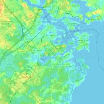
Name: Topografische Karte Portsmouth, Höhe, Relief.
Ort: Portsmouth, Rockingham County, New Hampshire, United States (43.01355 -70.82300 43.09961 -70.72793)
Durchschnittliche Höhe: 9 m
Minimale Höhe: -5 m
Maximale Höhe: 33 m
Andere topografische Karten
Klicken Sie auf eine Karte, um ihre Topografie, ihre Höhe und ihr Relief anzuzeigen.
Jenness Beach
United States > New Hampshire > Rockingham County > Rye > Rye Beach Village District
Jenness Beach, Rye Beach Village District, Rye, Rockingham County, New Hampshire, United States
Durchschnittliche Höhe: 5 m
Northwood
United States > New Hampshire > Rockingham County
Northwood, Rockingham County, New Hampshire, 03261, United States
Durchschnittliche Höhe: 167 m
Stratham
United States > New Hampshire > Rockingham County
Stratham, Rockingham County, New Hampshire, 03885, United States
Durchschnittliche Höhe: 22 m
Newington
United States > New Hampshire > Rockingham County > Newington
Newington, Rockingham County, New Hampshire, 03801-2819, United States
Durchschnittliche Höhe: 10 m