
Topografische Karte Stratham
Interaktive Karte
Klicken Sie auf die Karte, um die Höhe anzuzeigen.
Über diese Karte
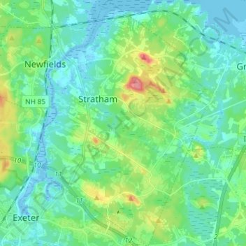
Name: Topografische Karte Stratham, Höhe, Relief.
Durchschnittliche Höhe: 22 m
Minimale Höhe: -10 m
Maximale Höhe: 85 m
According to the United States Census Bureau, the town has a total area of 15.5 square miles (40.2 km2), of which 15.1 square miles (39.2 km2) are land and 0.3 square miles (0.9 km2) are water, comprising 2.29% of the town. Most of Stratham is drained by the Squamscott River, a north-flowing tributary of Great Bay. The east side of the town drains to the Winnicut River, which also flows to Great Bay. The entire town is part of the Piscataqua River watershed. The highest elevation in town is 290 feet (88 m) above sea level, found on the summits of Stratham Hill and neighboring Jewell Hill, both glacial drumlins.
Andere topografische Karten
Klicken Sie auf eine Karte, um ihre Topografie, ihre Höhe und ihr Relief anzuzeigen.
Jenness Beach
United States > New Hampshire > Rockingham County > Rye > Rye Beach Village District
Jenness Beach, Rye Beach Village District, Rye, Rockingham County, New Hampshire, United States
Durchschnittliche Höhe: 5 m
Northwood
United States > New Hampshire > Rockingham County
Northwood, Rockingham County, New Hampshire, 03261, United States
Durchschnittliche Höhe: 167 m
Portsmouth
United States > New Hampshire > Rockingham County
Portsmouth, Rockingham County, New Hampshire, United States
Durchschnittliche Höhe: 9 m
Newington
United States > New Hampshire > Rockingham County > Newington
Newington, Rockingham County, New Hampshire, 03801-2819, United States
Durchschnittliche Höhe: 10 m