
Topografische Karte Victoria
Interaktive Karte
Klicken Sie auf die Karte, um die Höhe anzuzeigen.
Über diese Karte
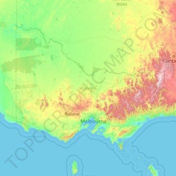
Name: Topografische Karte Victoria, Höhe, Relief.
Ort: Victoria, Australien (-39.19849 140.96190 -33.98080 150.03328)
Durchschnittliche Höhe: 179 m
Minimale Höhe: -2 m
Maximale Höhe: 2.174 m
Andere topografische Karten
Klicken Sie auf eine Karte, um ihre Topografie, ihre Höhe und ihr Relief anzuzeigen.
4160
4160, Wellington Point, Greater Brisbane, Redland City, Queensland, Australien
Durchschnittliche Höhe: 6 m
Canberra
Canberra, District of Canberra Central, Australisches Hauptstadtterritorium, 2600, Australien
Durchschnittliche Höhe: 638 m
Lobethal
Lobethal, Adelaide Hills Council, Südaustralien, 5241, Australien
Durchschnittliche Höhe: 445 m
Sterling River
Australien > Tasmanien > Tullah
Sterling River, Tullah, West Coast, Tasmanien, Australien
Durchschnittliche Höhe: 246 m
Australisches Hauptstadtterritorium
Australisches Hauptstadtterritorium, Australien
Durchschnittliche Höhe: 971 m
Riverton
Riverton, Clare and Gilbert Valleys Council, Südaustralien, 5412, Australien
Durchschnittliche Höhe: 316 m
Lithgow City Council
Lithgow City Council, Neusüdwales, Australien
Durchschnittliche Höhe: 713 m
McDonald-Insel
McDonald-Insel, Heard und McDonaldinseln, Australien
Durchschnittliche Höhe: 26 m
Lucindale
Australien > Südaustralien > Naracoorte Lucindale Council
Lucindale, Naracoorte Lucindale Council, Südaustralien, 5272, Australien
Durchschnittliche Höhe: 34 m
Ingham
Ingham, Hinchinbrook Shire, Queensland, Australien
Durchschnittliche Höhe: 13 m
The Barossa Council
The Barossa Council, Südaustralien, Australien
Durchschnittliche Höhe: 308 m
Saint Peter Island
Saint Peter Island, Südaustralien, Australien
Durchschnittliche Höhe: 4 m
Bendigo
Bendigo, City of Greater Bendigo, Victoria, 3550, Australien
Durchschnittliche Höhe: 223 m
Gold Creek Reservoir
Australien > Queensland > Brisbane
Gold Creek Reservoir, Layhys Break, Upper Brookfield, Brisbane, Queensland, 4520, Australien
Durchschnittliche Höhe: 161 m
Dedin
Dedin, Douglas Shire, Queensland, Australien
Durchschnittliche Höhe: 551 m
Tatiara District Council
Australien > Südaustralien > Tatiara District Council
Tatiara District Council, Südaustralien, Australien
Durchschnittliche Höhe: 71 m
Mungo National Park
Mungo National Park, Balranald Shire Council, Neusüdwales, Australien
Durchschnittliche Höhe: 81 m
Griers Creek
Griers Creek, Tweed Shire Council, Neusüdwales, Australien
Durchschnittliche Höhe: 196 m
Brisbane
Australien > Queensland > Brisbane
Brisbane, Queensland, 4000, Australien
Durchschnittliche Höhe: 45 m
Yulara
Australien > Nordterritorium > Yulara
Yulara, Nordterritorium, Australien
Durchschnittliche Höhe: 507 m
Gold Coast
Australien > Queensland > Gold Coast
Gold Coast, Queensland, 4217, Australien
Durchschnittliche Höhe: 42 m
Brompton
Brompton, Charles Sturt, Südaustralien, 5007, Australien
Durchschnittliche Höhe: 24 m
Trentham
Australien > Victoria > Trentham
Trentham, Shire of Hepburn, Grampians, Victoria, 3458, Australien
Durchschnittliche Höhe: 713 m
Laverton
Australien > Westaustralien > Laverton
Laverton, Westaustralien, 6440, Australien
Durchschnittliche Höhe: 461 m
Hyden
Australien > Westaustralien > Hyden
Hyden, Westaustralien, 6359, Australien
Durchschnittliche Höhe: 312 m
Pambula
Australien > Neusüdwales > Pambula
Pambula, Bega Valley, Neusüdwales, 2549, Australien
Durchschnittliche Höhe: 47 m
Sydney CBD
Australien > Neusüdwales > Sydney
Sydney CBD, Sydney, Neusüdwales, 2000, Australien
Durchschnittliche Höhe: 23 m
Glenorchy
Australien > Tasmanien > Glenorchy
Glenorchy, Tasmanien, 7010, Australien
Durchschnittliche Höhe: 122 m
Peeramon
Australien > Queensland > Peeramon
Peeramon, Queensland, Australien
Durchschnittliche Höhe: 745 m
Logandale
Australien > Queensland > Logandale
Logandale, Queensland, 4130, Australien
Durchschnittliche Höhe: 15 m
Mutitjulu
Australien > Nordterritorium > Mutitjulu
Mutitjulu, Nordterritorium, Australien
Durchschnittliche Höhe: 532 m
Middle Harbour
Australien > Neusüdwales > Sydney
Middle Harbour, Sydney, Neusüdwales, 2087, Australien
Durchschnittliche Höhe: 56 m
Williamstown
Williamstown, Barossa, Südaustralien, 5351, Australien
Durchschnittliche Höhe: 310 m
Alpine NP
Alpine NP, Harrietville, Alpine Shire, Hume, Victoria, 3723, Australien
Durchschnittliche Höhe: 588 m
Dubbo
Australien > Neusüdwales > Dubbo
Dubbo, Western Plains, Neusüdwales, Australien
Durchschnittliche Höhe: 307 m
Great Sandy National Park
Australien > Queensland > Hervey Bay
Great Sandy National Park, Hervey Bay, Queensland, Australien
Durchschnittliche Höhe: 32 m
Lara
Australien > Victoria > Geelong
Lara, Cohuna Court, Corio, Geelong, City of Greater Geelong, Barwon South West, Victoria, 3214, Australien
Durchschnittliche Höhe: 94 m
Hattah - Kulkyne NP
Australien > Victoria > Colignan
Hattah - Kulkyne NP, Reed Road, Hattah, Colignan, Rural City of Mildura, Loddon Mallee, Victoria, Australien
Durchschnittliche Höhe: 51 m
Lake Mackay
Lake Mackay, Central Desert Region, Nordterritorium, Australien
Durchschnittliche Höhe: 430 m
Mount Tibberoowuccum
Australien > Queensland > Caboolture
Mount Tibberoowuccum, Caboolture, Queensland, 4518, Australien
Durchschnittliche Höhe: 49 m
Mount Coonowrin
Australien > Queensland > Caboolture
Mount Coonowrin, Caboolture, Queensland, Australien
Durchschnittliche Höhe: 78 m
Carlisle Island
Australien > Queensland > Mackay
Carlisle Island, Mackay, Queensland, Australien
Durchschnittliche Höhe: 64 m
Mount Cooee
Australien > Queensland > Caboolture
Mount Cooee, Caboolture, Queensland, 4518, Australien
Durchschnittliche Höhe: 42 m
Flinders River
Flinders River, Queensland, Australien
Durchschnittliche Höhe: 107 m