
Topografische Karte Chinchiná
Interaktive Karte
Klicken Sie auf die Karte, um die Höhe anzuzeigen.
Über diese Karte
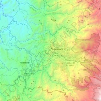
Name: Topografische Karte Chinchiná, Höhe, Relief.
Durchschnittliche Höhe: 1.965 m
Minimale Höhe: 749 m
Maximale Höhe: 4.732 m
Andere topografische Karten
Klicken Sie auf eine Karte, um ihre Topografie, ihre Höhe und ihr Relief anzuzeigen.
Nevado del Ruiz
Nevado del Ruiz, Villamaría, Centrosur, Caldas, Colombia
Durchschnittliche Höhe: 5.051 m
Villamaría
Colombia > Caldas > Villamaría
Villamaría, Centrosur, Caldas, Colombia
Durchschnittliche Höhe: 2.403 m
Comuna Tesorito
Colombia > Caldas > Comuna Tesorito
Comuna Tesorito, Manizales, Centrosur, Caldas, Colombia
Durchschnittliche Höhe: 2.198 m