
Topografische Karte Bell County
Interaktive Karte
Klicken Sie auf die Karte, um die Höhe anzuzeigen.
Über diese Karte
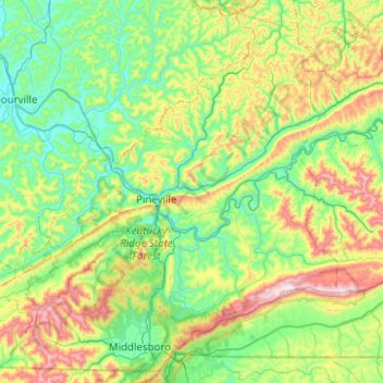
Name: Topografische Karte Bell County, Höhe, Relief.
Ort: Bell County, Kentucky, USA (36.58258 -83.95724 36.95599 -83.45902)
Durchschnittliche Höhe: 498 m
Minimale Höhe: 286 m
Maximale Höhe: 1.049 m
Andere topografische Karten
Klicken Sie auf eine Karte, um ihre Topografie, ihre Höhe und ihr Relief anzuzeigen.
Tigers
USA > Kentucky > Louisville
Tigers, Louisville, Jefferson County, Kentucky, USA
Durchschnittliche Höhe: 155 m
Shelbyville
USA > Kentucky > Shelbyville
Shelbyville, Shelby County, Kentucky, 40065, USA
Durchschnittliche Höhe: 232 m
Georgetown
USA > Kentucky > Georgetown
Georgetown, Scott County, Kentucky, 40324, USA
Durchschnittliche Höhe: 265 m