
Topografische Karte Robertson County
Interaktive Karte
Klicken Sie auf die Karte, um die Höhe anzuzeigen.
Über diese Karte
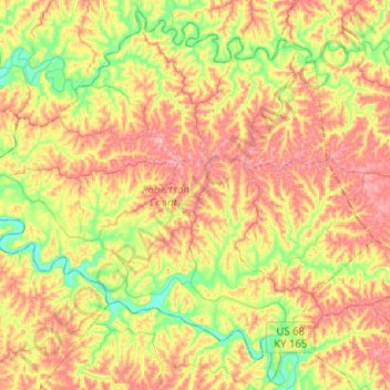
Name: Topografische Karte Robertson County, Höhe, Relief.
Ort: Robertson County, Kentucky, 41064, USA (38.42021 -84.18392 38.60855 -83.93005)
Durchschnittliche Höhe: 239 m
Minimale Höhe: 173 m
Maximale Höhe: 305 m
Andere topografische Karten
Klicken Sie auf eine Karte, um ihre Topografie, ihre Höhe und ihr Relief anzuzeigen.
Tigers
USA > Kentucky > Louisville
Tigers, Louisville, Jefferson County, Kentucky, USA
Durchschnittliche Höhe: 155 m
Shelbyville
USA > Kentucky > Shelbyville
Shelbyville, Shelby County, Kentucky, 40065, USA
Durchschnittliche Höhe: 232 m
Georgetown
USA > Kentucky > Georgetown
Georgetown, Scott County, Kentucky, 40324, USA
Durchschnittliche Höhe: 265 m