
Topografische Karte Kellogg
Interaktive Karte
Klicken Sie auf die Karte, um die Höhe anzuzeigen.
Über diese Karte
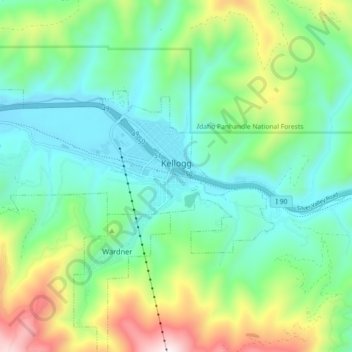
Name: Topografische Karte Kellogg, Höhe, Relief.
Ort: Kellogg, Shoshone County, Idaho, 83837, United States (47.52081 -116.18408 47.55095 -116.09384)
Durchschnittliche Höhe: 939 m
Minimale Höhe: 682 m
Maximale Höhe: 1.596 m
Kellogg is located at 47°32′18″N 116°07′31″W / 47.53833°N 116.12528°W / 47.53833; -116.12528 (47.538391, -116.125406), at an elevation of 2,303 feet (702 m) above sea level.
Andere topografische Karten
Klicken Sie auf eine Karte, um ihre Topografie, ihre Höhe und ihr Relief anzuzeigen.
South Butte
United States > Idaho > Shoshone County
South Butte, Shoshone County, Idaho, United States
Durchschnittliche Höhe: 1.861 m
Turkey Point
United States > Idaho > Shoshone County
Turkey Point, Shoshone County, Idaho, United States
Durchschnittliche Höhe: 1.604 m
tiger peak
United States > Idaho > Shoshone County
tiger peak, Shoshone County, Idaho, United States
Durchschnittliche Höhe: 1.711 m
Kingston
United States > Idaho > Shoshone County
Kingston, Shoshone County, Idaho, 83839, United States
Durchschnittliche Höhe: 730 m
Wallace
United States > Idaho > Shoshone County
Wallace, Shoshone County, Idaho, 83873, United States
Durchschnittliche Höhe: 991 m
Spion Kop
United States > Idaho > Shoshone County
Spion Kop, Shoshone County, Idaho, United States
Durchschnittliche Höhe: 1.436 m
McDonalds
United States > Idaho > Shoshone County
McDonalds, Shoshone County, Idaho, United States
Durchschnittliche Höhe: 1.692 m