
Topografische Karte South Butte
Interaktive Karte
Klicken Sie auf die Karte, um die Höhe anzuzeigen.
Über diese Karte
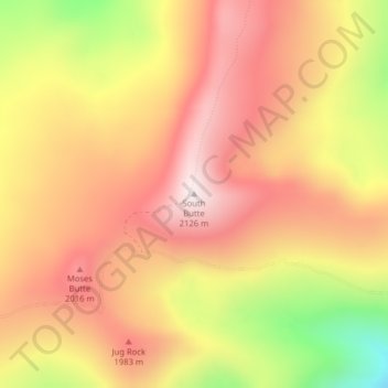
Name: Topografische Karte South Butte, Höhe, Relief.
Ort: South Butte, Shoshone County, Idaho, United States (47.02014 -115.80798 47.02024 -115.80788)
Durchschnittliche Höhe: 1.861 m
Minimale Höhe: 1.442 m
Maximale Höhe: 2.122 m
Andere topografische Karten
Klicken Sie auf eine Karte, um ihre Topografie, ihre Höhe und ihr Relief anzuzeigen.
Turkey Point
United States > Idaho > Shoshone County
Turkey Point, Shoshone County, Idaho, United States
Durchschnittliche Höhe: 1.604 m
Kellogg
United States > Idaho > Shoshone County
Kellogg, Shoshone County, Idaho, 83837, United States
Durchschnittliche Höhe: 939 m
tiger peak
United States > Idaho > Shoshone County
tiger peak, Shoshone County, Idaho, United States
Durchschnittliche Höhe: 1.711 m
Kingston
United States > Idaho > Shoshone County
Kingston, Shoshone County, Idaho, 83839, United States
Durchschnittliche Höhe: 730 m
Wallace
United States > Idaho > Shoshone County
Wallace, Shoshone County, Idaho, 83873, United States
Durchschnittliche Höhe: 991 m
Spion Kop
United States > Idaho > Shoshone County
Spion Kop, Shoshone County, Idaho, United States
Durchschnittliche Höhe: 1.436 m
McDonalds
United States > Idaho > Shoshone County
McDonalds, Shoshone County, Idaho, United States
Durchschnittliche Höhe: 1.692 m