
Topografische Karte Polaris
Interaktive Karte
Klicken Sie auf die Karte, um die Höhe anzuzeigen.
Über diese Karte
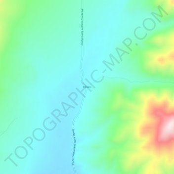
Name: Topografische Karte Polaris, Höhe, Relief.
Ort: Polaris, Beaverhead County, Montana, United States (45.34965 -113.13949 45.38965 -113.09949)
Durchschnittliche Höhe: 2.016 m
Minimale Höhe: 1.910 m
Maximale Höhe: 2.369 m
Andere topografische Karten
Klicken Sie auf eine Karte, um ihre Topografie, ihre Höhe und ihr Relief anzuzeigen.
Jackson
United States > Montana > Beaverhead County
Jackson, Beaverhead County, Montana, 59736, United States
Durchschnittliche Höhe: 1.995 m
Monida
United States > Montana > Beaverhead County
Monida, Beaverhead County, Montana, United States
Durchschnittliche Höhe: 2.111 m
Dillon
United States > Montana > Beaverhead County
Dillon, Beaverhead County, Montana, United States
Durchschnittliche Höhe: 1.562 m